May 1-7, 2017
Midwest Weekly Highlights - May 1-7, 2017
More Heavy Rainfall
Another large storm crossed the Midwest during the first week of May, bringing heavy rainfall to Missouri, Illinois, Indiana, Ohio and Lower Michigan
(Figure 1). Amounts of 3-5 inches for the week were common across Missouri, southern Illinois and Indiana. The system that caused the initial flooding in Missouri during the last week of April continued to drop rain across the entire Midwest through the morning of May 1 (Figure 2). The next system began several days later on May 3 through the morning of May 4
(Figure 3). Parts of Missouri and southern Illinois had 1-3 inches of rainfall. The storm moved east through the morning of May 5, dumping 1-2 inches of rain throughout Indiana (Figure 4). Up to another inch of rainfall fell in southeastern Indiana and northwestern Ohio through the morning of May 6
(Figure 5). Many of the areas receiving heavy rainfall had more than twice the normal amount, with some receiving more than three times the normal amount (Figure 6). During the period, over 175 daily precipitation records were broken
(Figure 7).
Flooding Continues in Missouri, Illinois and Indiana
Flooding continued across Missouri, southern Illinois and Indiana during the week (Figure 8). The slow-moving storm on May 3-6 exacerbated flooding in Missouri and southern Illinois, while causing it across Indiana.
Missouri
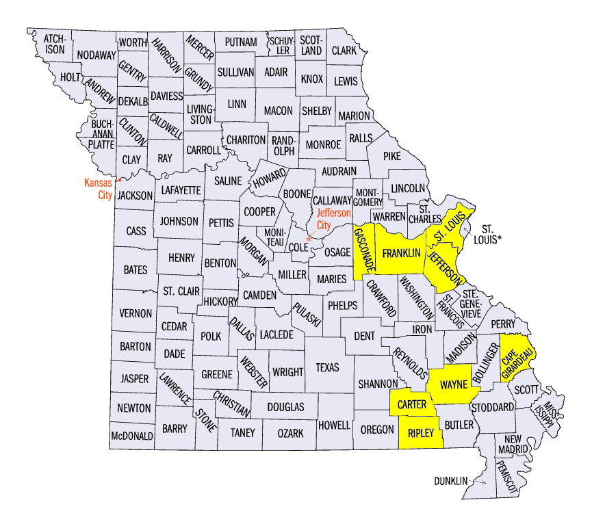
Most of Missouri dealt with flooding throughout the week (Figure 9). Major flooding continued along most of the Meramec River. Several gauges that neared record flood stage included Pacific (Figure 10, Franklin County), Eureka (Figure 11, St. Louis County), and Arnold (Figure 12, Jefferson County). Crests on the Missouri River reached major flood stage at Gasconade (Figure 13, Gasconade County), Hermann (Figure 14, Gasconade County), and Washington (Figure 15, Franklin County). Record crests also happened on the Current River at Van Buren (Figure 16, Carter County) and Doniphan (Figure 17, Ripley County) and on the St. Francis River near Patterson (Figure 18, Wayne County). Hundreds of roads were closed across Missouri during the week. According to the Missouri Department of Transportation, 270 roads were closed on May 2, with 233 still closed on May 4 and 190 on the morning of May 5. Parts of I-44 and I-55 were blocked until May 5, causing major traffic issues around St. Louis.
Illinois
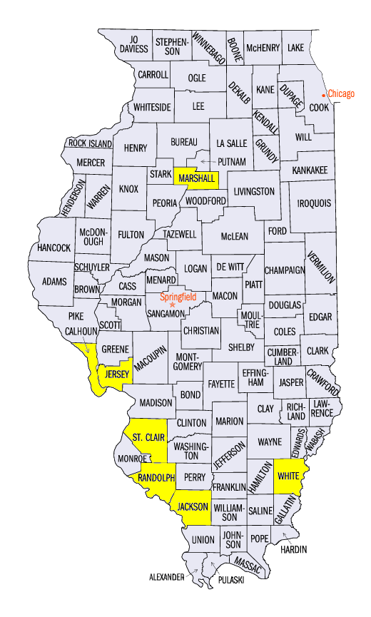
Minor to moderate flooding remained common across southern Illinois and along the Illinois River (Figure 19). The Kaskaskia, Big Muddy, Little Wabash and Embarrass rivers all reached moderate flood stage during the week. Major flood stage occurred at several gauges as well, including at Carmi (Figure 20, White County), Murphysboro (Figure 21, Jackson County), and New Athens (Figure 22, St. Clair County). Moderate to major flooding was observed along the Illinois River from Henry (Marshall County) through the mouth at the Mississippi River. Major flooding was common throughout the week on the river at Hardin (Figure 23, Calhoun County).
Indiana
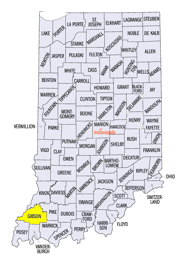
After rivers began to recede from rainfall during the last week of April across Indiana, heavy rain on May 4-5 led many stream gauges to reach flood stage once again across the state (Figure 24). Moderate flooding was common along the White and Wabash rivers. This included the Indianapolis (Figure 25) and Lafayette (Figure 26) areas and downstream. Major flood stage was reached on the Patoka River near Princeton (Figure 27, Gibson County) on May 6.
Mississippi River
Flooding along the Mississippi River occurred during the week from New Boston, IL through the Missouri Bootheel. The worst flooding was concentrated from the St. Louis area through the Cape Girardeau, MO area. Six stream gauges along the river reached major flood stage, including Grafton, IL (Figure 28, Jersey County), St. Louis, MO (Figure 29), Chester, IL (Figure 30, Randolph County), and Cape Girardeau, MO (Figure 31, Cape Girardeau County). Moderate flooding also occurred near the mouth of the Ohio River.
Cold Start to May
Temperatures were below normal across most of the Midwest during the first week of May (Figure 32) Most of Illinois and Indiana were 5-9°F below normal, with Iowa, Missouri, Wisconsin, Michigan, Ohio and Kentucky 2-5°F below normal. Only northwestern Minnesota had average temperatures above normal. Maximum temperatures were a major influence, as Illinois, Indiana, western Ohio and Michigan were 8-12°F below normal (Figure 1). Maximum temperatures were often in the low 50s, and even in the upper 40s across areas where heavy rainfall was occurring, including through the mornings of May 4 (Figure 34) and May 5 (Figure 35). Over 150 daily low maximum temperature records were broken during the period (Figure 36).
Midwest Free of Drought and Abnormally Dry Conditions
For the first time since May 2002, the Midwest was free of drought and abnormally dry conditions in all nine states according to the May 2 U.S. Drought Monitor (Figure 37). This was also only the second week since the U.S. Drought Monitor began in January 2000 that the Midwest had no drought concerns. Heavy rain during the last week of April into the first few days of May aided in eliminating all remaining abnormally dry conditions in Missouri, southeastern Iowa and the northern Ohio Valley from the week prior.
-BJP-