December 1-10, 2018
Midwest Weekly Highlights - December 1-10, 2018
Cold Remains
Temperatures remained cold across the Midwest, as most of the region had average temperatures below normal
(Figure 1). Most of Missouri, southern Iowa, central Illinois and northern Indiana were 3-5°F below normal, with northern Iowa, southern Wisconsin, Michigan and Ohio 1-3°F below normal. Parts of Kentucky, northern Wisconsin and Minnesota were near normal, while northern Minnesota was the lone area above normal. Maximum temperatures were a major contributor to the cold, as most of the region was 3°F or more below normal (Figure 2). Missouri and western Iowa were 5-8°F below normal.
Winter Storm, then Mainly Dry
A single winter storm during the first few days of the period accounted for most of the precipitation during the week
(Figure 3). Most of this precipitation fell across the southern Midwest through the mornings of December 1 (Figure 4) and December 2
(Figure 5), where combined amounts of over 1 inch were common. Southern areas in Kentucky had more than 1.50 inches. However, this was only near the normal range of amounts for the period in the Ohio River Valley (Figure 6). In northern Lower Michigan, southern Wisconsin, Iowa, and northern Missouri, precipitation amounts were well above normal, however. More than 100 daily precipitation records were broken during the period
(Figure 7), with most occurring on December 1-2. Areas in western Iowa and northwestern Missouri had more than twice the normal amount. Snow was also common from western Iowa through the U.P. of Michigan (Figure 8). Amounts of over 5 inches were common in northwestern Iowa, southern Minnesota, and the U.P. of Michigan.
December 1-2 Winter Storm and Tornado Outbreak
A winter storm coupled with a strong gradient in temperatures led to a snowstorm from Iowa through Michigan and a tornado outbreak in Illinois. The storm began gaining strength over Oklahoma and Kansas during the early morning hours of December 1 (Figure 9) before stalling over eastern Kansas by the afternoon (Figure 10). Strong frontal boundaries and increased moisture from southerly flow ahead of the storm’s frontal boundaries led to active weather throughout the Midwest.
December 1 Illinois Tornado Outbreak
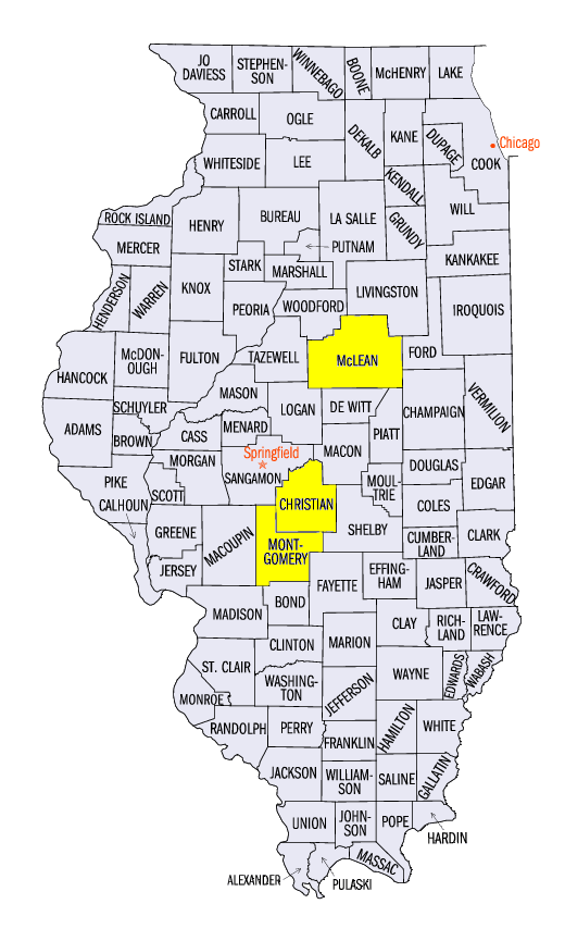
The most prolific tornado outbreak across Illinois in December according to the National Weather Service occurred on December 1 when 28 tornadoes touched down across central and western Illinois (Figure 11). The 28 tornadoes in Illinois were also the third highest total from a single outbreak in the state. These tornadoes combined to cause 23 injuries, with fortunately no fatalities reported. Ratings for these tornadoes ranged from EF-0 to EF-3 and occurred over nearly a six hour period from 2pm to 8pm central standard time. Ten of the tornadoes were rated EF-0, 14 were rated EF-1, three EF-2, and one EF-3. The three EF-2 tornadoes impacted Moraine View State Park (McLean County), Stonington (Christian County) and the Litchfield/Bulter area (Montgomery County). All three of these tornadoes had estimated wind speeds near 115 mph.
The EF-3 tornado inflicted major damage to structures as it passed through the city of Taylorville (Christian County) during the early evening hours. National Weather Service surveys determined that more than 500 homes were damaged, with nearly 100 suffering major or severe damage. Injuries to 22 people were also reported. Maximum winds were estimated at 155 mph and the path reached as wide as a half mile along a nearly 13 mile long path.
Iowa, Wisconsin and Michigan Snowfall
Heavy snow on the northwest side of the storm brought heavy snow to northern Iowa and southern Minnesota through Michigan through the mornings of December 1 through the morning of December 2
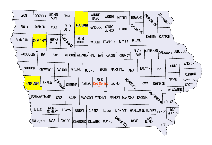
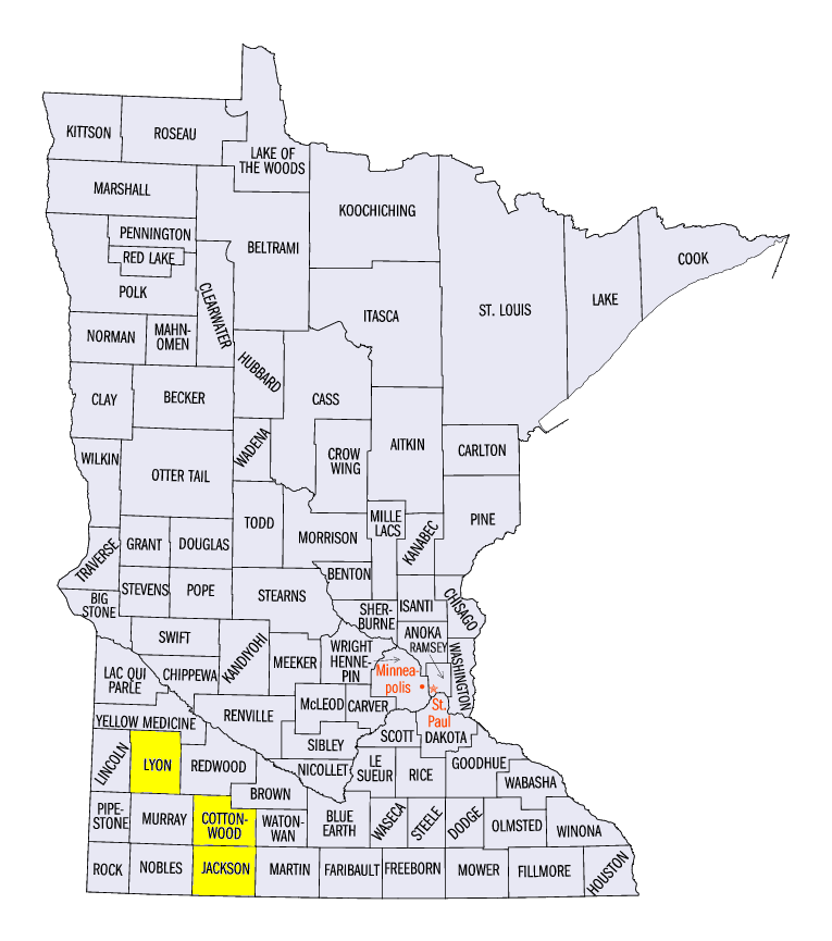
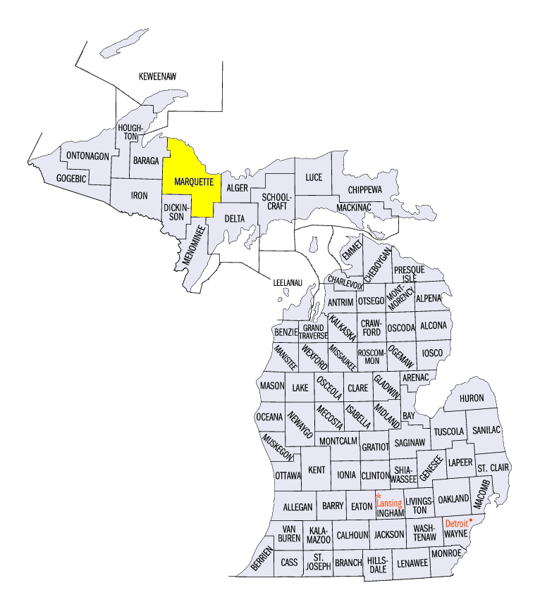
(Figure 12). Amounts of 4-8 inches fell in northern Iowa and southern Minnesota, while lake-effects through the morning of December 3 (Figure 13) helped totals in the U.P. of Michigan reach near a foot. In Iowa amounts included 8.0 inches in Cherokee (Cherokee County), 7.8 inches near Swea City (Kossuth County) and 7.5 inches near Little Sioux (Harrison County). In Minnesota, amounts included 11.0 inches near Lakefield (Jackson County), 8.3 inches in Windom (Cottonwood County) and 8.0 inches in Tracy (Lyon County). More than 20 daily snowfall records were broken in Iowa and Minnesota from snow through the morning of December 2. Several reports of more than a foot of snow were also reported in Marquette County, MI for snowfall from December 1-3.
-BJP-