July 18-24, 2018
Midwest Weekly Highlights - July 18-24, 2018
Large-Scale Summer Storm
A strong large-scale storm tracked across the Midwest during the period
(Figure 1). Precipitation amounts varied across the region, with areas in the Ohio River Valley, southern Wisconsin and western Minnesota receiving heavier amounts. The storm moved into the western parts of the region on July 19, with the majority of the rainfall occurring through the morning of July 22. Parts of eastern Kentucky received more than three inches, while west-central Minnesota and northeastern Indiana had more than two inches. In most cases, this was more than twice the normal amount (Figure 2). Several dozen precipitation records were broken during the period
(Figure 3), mainly in these areas. Meanwhile, Illinois, western Iowa, Missouri and areas around Lake Superior remained relatively dry. Some areas in western Iowa and along the southern Illinois and Missouri border had less than a tenth of an inch for the period.
Temperatures Finally Cool Off
Temperatures were cooler than normal across a large portion of the Midwest during the week (Figure 4) as a storm allowed cooler Canadian air to dive south into the region. Since a very cold month of April, the majority of the Midwest had gone largely without an extended break from warmer than normal temperatures, until this week. Most of Illinois, Indiana, Kentucky and western Ohio were 2-4°F below normal, while parts of Iowa, northern Missouri, southern Minnesota, Wisconsin and Michigan were 1-3°F below normal. A few areas in northern Minnesota and the eastern U.P. of Michigan were slightly above normal. Several dozen low temperature records were broken or tied
(Figure 5), with many of these from low maximum temperatures. Maximum temperatures in Illinois and eastern Ohio were 4-6°F below normal (Figure 6).
July 19 Iowa Tornadoes, Missouri Winds
Several large and destructive tornadoes impacted central Iowa on July 19 (Figure 7). In total, 12 tornadoes were confirmed, with two rated as EF-3. One of these EF-3 tornadoes tracked through the northeastern edge of Pella (Marion County) with estimated peak winds of 144 mph. At least six injuries were reported, with no fatalities. A second EF-3 tornado leveled many houses and structures as it directly hit Marshalltown (Marshall County). Estimated peak winds were 144 mph. At least fifty buildings were destroyed with hundreds more damaged. A heating and cooling factory in the city was also heavily damaged. An EF-2 tornado was also reported in Bondurant (Polk County) with estimated winds of 115 mph.
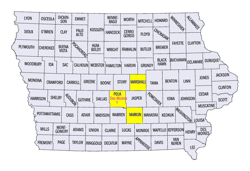
Further south, strong winds from storms in eastern Kansas through southwestern Missouri during the afternoon and evening hours caused widespread damage. A 78 mph wind gust was reported at the Whiteman Air Force Base (Johnson County). Large hail up to 2.75 inches was also reported in Lone Jack (Jackson County) and Stasburg (Cass County). A severe thunderstorm with strong winds impacted the Branson area (Taney and Stone counties) during the evening hours while an amphibious “duck” boat was on nearby Table Rock Lake. Seventeen people on the boat drowned when the boat capsized in the strong winds.
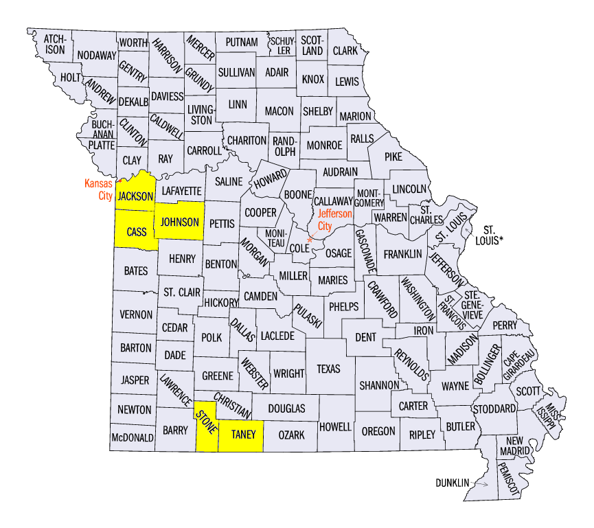
July 20 Kentucky, Indiana Severe Weather
Strong thunderstorms and several tornadoes impacted Kentucky, Indiana and several other states on July 20 (Figure 8). In total, 230 reports of wind, tornadoes and hail occurred on July 20. Eight reports of two-inch diameter hail or larger were observed. The largest of these hailstones was 4 inches in diameter in Tompkinsville, KY (Monroe County). Winds of 60-70 mph were reported across central Kentucky and Indiana. Injuries were reported in Michigan City, IN (La Porte County) and in Norwood, OH (Hamilton County) when trees fell on vehicles. Two weak EF-0 tornadoes were reported near Edmonton, KY (Metcalfe County) and near Priceville, KY (Hart County), while an EF-1 tornado was reported near Central, IN (Harrison County). Another weak tornado was reported in central Indiana and central Wisconsin. Several reports hail were also reported in southern Missouri.
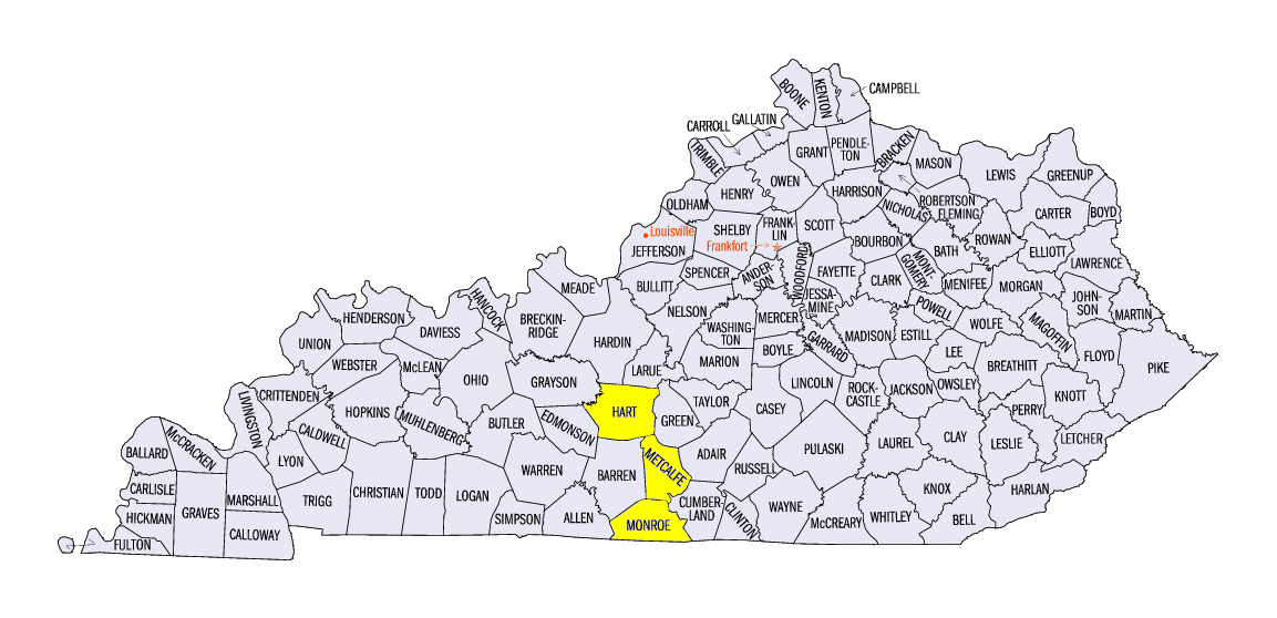
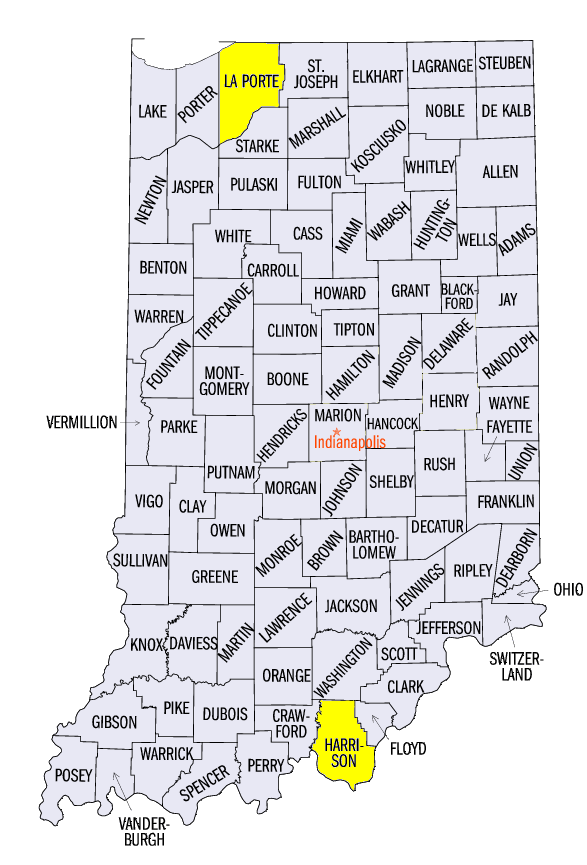
Drought in Missouri, Michigan Expands
Drought in Missouri and Lower Michigan expanded in the July 24 U.S. Drought Monitor (Figure 9). More than 50 percent of Missouri was considered to be in drought, with more than 15 percent in extreme drought (Figure 10). According to the drought summary, the USDA reported that some farmers in the state have given up on their corn crop, as little to no development of ears were present. Around three-fourths of the state also reported short to very short topsoil and subsoil moisture.
Meanwhile, moderate drought continued to expand in Lower Michigan
(Figure 11). Drought was introduced into several counties in south-central Lower Michigan, as areas affected by drought nearly doubled for the state. The drought summary reported that more than two-thirds of the state reported short to very short soil moisture, while soybean leaves were flipped. Abnormally dry conditions also expanded in north-central Wisconsin and northern Minnesota.
-BJP-