November 10-16, 2019
Midwest Weekly Highlights - November 10-16, 2019
Extreme Cold
Arctic air invaded the Midwest leading most of the region 10°F or more below normal
(Figure 1). Areas in Illinois were even colder at 14-16°F below normal. The Arctic blast began through the morning of November 11 in the Upper Midwest (Figure 2). The mornings of November 12
(Figure 3) and November 13 (Figure 4) were the coldest during the period. Temperatures in the single digits above and below zero were widespread. Minimum temperatures in the teens persisted through the remainder of the period. These temperatures led to more than 1,300 daily low maximum and low minimum temperature records during the period
(Figure 5). More than 850 of these records occurred through the mornings of November 12 (Figure 6) and November 13 alone
(Figure 7).
Drier, With Snowfall
Precipitation across the Midwest was minimal for most areas (Figure 8). Only a few areas in the Great Lakes had more than half an inch, while northern Missouri, Minnesota and parts of Iowa and Wisconsin had less than a tenth of an inch. This resulted in most of the region receiving less than half the normal amount for the period (Figure 9). Only a few spotty areas in the Great Lakes had above normal precipitation.
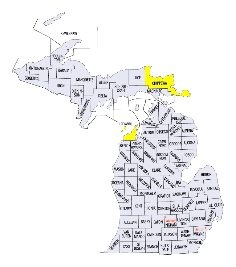
Most of this precipitation fell in the form of snowfall, with only a few areas in the region not receiving measurable snowfall during the period (Figure 10). Lake-effect snowfall in Michigan, northern Indiana and northern Ohio led to more than five inches, with isolated amounts over a foot in northwestern Lower Michigan. Some of the heaviest amounts included 29 inches at the Northwestern Michigan Research Farm (Leelanau County), 24.8 inches near Northport (Leelanau County) and 22.7 inches in Paradise (Chippewa County).
Midwest Drought Free
The entire Midwest was free of drought for the first time since August 6 in the November 12 U.S. Drought Monitor
(Figure 11). Only a minor portion of southeastern Kentucky remained abnormally dry, with accounted for less than one percent of the region. Cited reasons for the improvement included drought declarations being lifted in Kentucky, while streamflow and soil moisture recovered.
Harvest Remains Behind
Snowfall and cold weather made fieldwork difficult across the Midwest as a significant amount of the region’s corn (Figure 12) and soybean
(Figure 13) crop remains unharvested. As of the November 10 USDA NASS Crop Progress Report, Only Kentucky has more than 80 percent of corn harvested. Iowa, Illinois and Minnesota were more than 20 percent behind the five-year average, with Michigan and Wisconsin more than 30 percent behind the five-year average. Soybeans were closer to full harvest, but delays remained in Wisconsin, which was 21 percent behind the five-year average. Kentucky was the only state above the five-year average in the Midwest.
-BJP-