July 14-21, 2019
Midwest Weekly Highlights - July 14-21, 2019
Heat Wave
A large heat dome covered the Midwest most of the week, leading to dangerous conditions
(Figure 1). Only a few areas in northern Minnesota and southern Missouri had temperatures near normal, while mean temperatures across most of Indiana and Ohio were 5-7°F above normal. While maximum temperatures were hot, minimum temperatures were a major contributor to the heat (Figure 2). Almost all of the more than 290 records broken during the period were from high minimum temperatures
(Figure 3). The largest spread of maximum temperatures in the 90s was on July 19 (Figure 4), before a cold front began to bring in cooler air on July 20
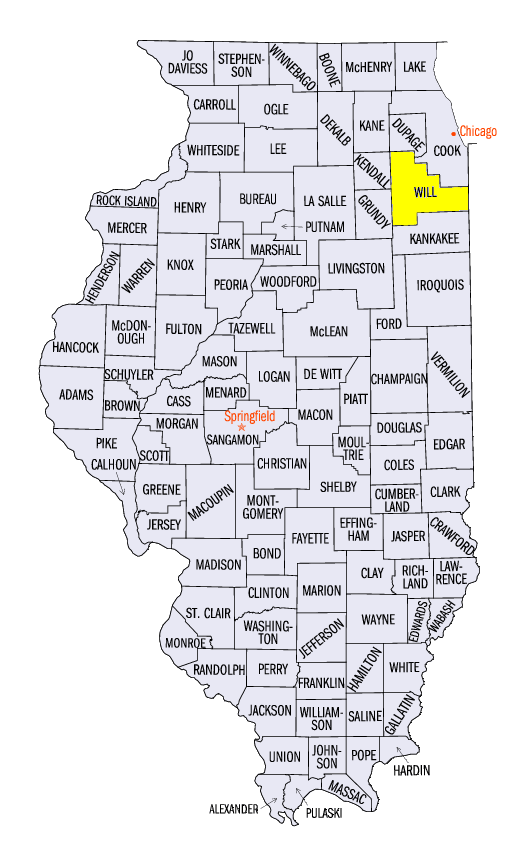
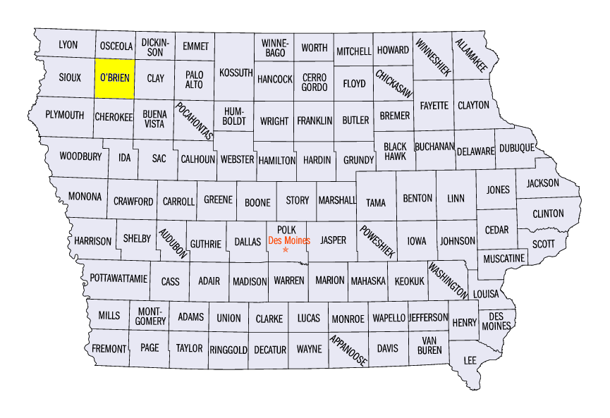
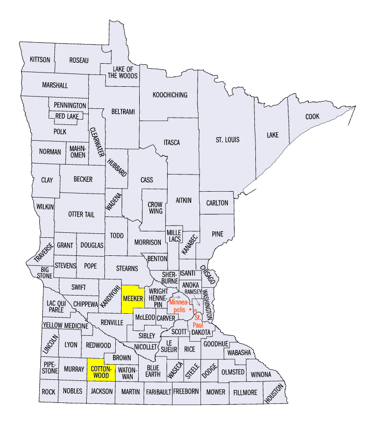
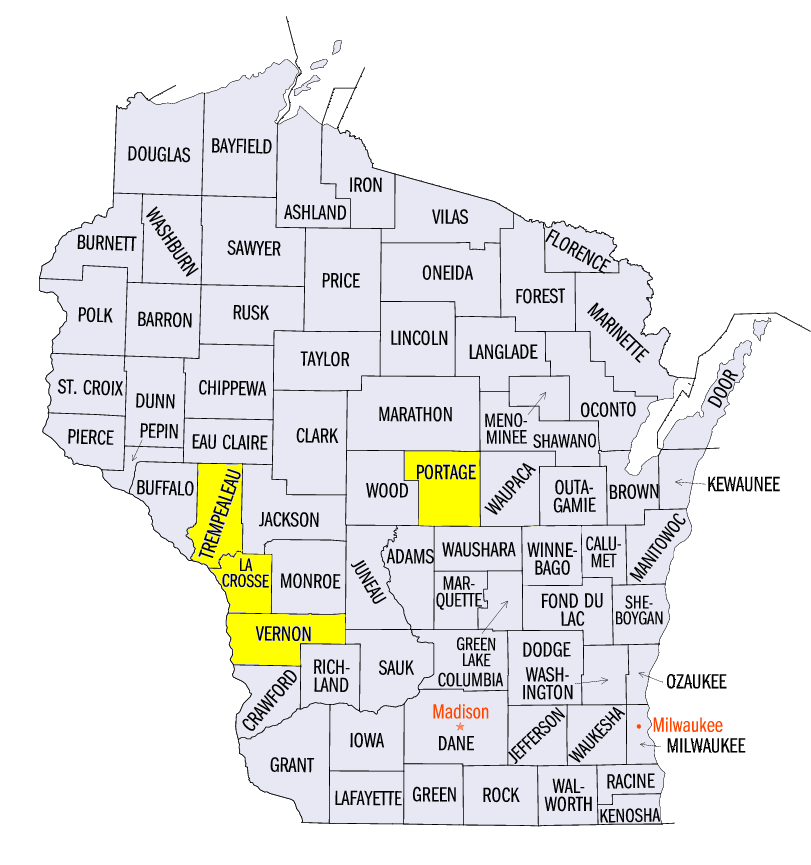
(Figure 5). Excessive Heat Warnings were in affect across a large portion of the Midwest from July 18-21 for heat index values in the 100s (Figure 6). The hottest values for several states in the region included 116°F in Joliet, IL (Will County), 124°F in Sheldon, IA (O’Brien County), 119°F in Litchfield, MN (Meeker County) and 118°F at La Crosse, WI (La Crosse County). Two deaths related to heat were reported in the Chicago area. A transmission fire in downtown Madison, WI also left many without power for cooling during the day on July 19.
Scattered Thunderstorms
Systems across the Upper Midwest and around the confluence of the Ohio and Mississippi rivers led to heavy rainfall, while other areas were very dry
(Figure 7). Amounts over three inches were common in Wisconsin, southeastern Minnesota and southeastern Missouri. Most of these areas had 2-3 times the normal amount, with a few areas with more than four times the normal amount (Figure 8). More than 100 daily precipitation records were broken across the region as a result
(Figure 9). Meanwhile, a large portion of central Illinois and southwestern Missouri had less than half an inch. Most of these areas had less than half the normal amount.
Widespread Severe Weather
Strong storms were common across the Midwest with reports on every day of the period (Figure 10). Many of these reports were centered in the Upper Midwest on July 19
(Figure 11) and July 20 (Figure 12) as two intense lines of thunderstorms pummeled Minnesota and Wisconsin. Large hail was common across west-central Minnesota as the storms formed on July 19, before strong winds went through forested areas in northern Wisconsin. Several weak tornadoes were also reported. Storms shifted slightly further south on July 20 into southern Minnesota and central Wisconsin. Strong winds toppled trees and power lines while several small tornadoes were reported. A 75 mph wind gust was reported near Windom, MN (Cottonwood County) and an 86 mph wind gust was reported near Plover, WI (Portage County). Two injuries were reported in Galesville, WI (Trempealeau County) from severe winds. In total, more than 500 reports of thunderstorm wind damage were reported across the region.
Wisconsin/Minnesota Flash Flooding July 18-19
Persistent rainfall along the I-90 corridor from Rochester, MN to La Crosse, WI on the evening of July 18 through the morning of July 19 led to flash flooding
(Figure 13). Rainfall amounts of 3-5 inches were common, with a high report of 5.74 inches near Westby, WI (Vernon County). Mudslides, damaged roads and rapidly rising rivers were all reported. The Kickapoo River in Ontario, WI (Vernon County) reached major flood stage for several hours overnight before receding in the morning (Figure 14).
Trying Growing Season Continues
After a near-record late planting season for most states in the Midwest, heat and lack of recent rainfall caused concern for abnormally dry conditions in several states. USDA Weekly Crop Progress reports for July 14 reported short or very short topsoil moisture in around 20 percent of Illinois, Indiana, Michigan, Missouri and Ohio. Despite the Midwest continuing to be free of drought in the July 18 U.S. Drought Monitor
(Figure 15), soil compaction from a wet spring could allow drier weather to quickly impact agriculture across the region. Silking of corn across the region remains well behind (Figure 16), with Indiana and Illinois more than 40 percent behind the five-year average. Reports of Good to Excellent corn condition were also down in every state in the Midwest compared to 2018
(Figure 17). This included Missouri, where drought was expanding during the previous summer (Figure 18).
-BJP-