January 22-31, 2019
Midwest Weekly Highlights - January 22-31, 2019
January 29-February 1 Arctic Air Outbreak
A partition of the polar vortex was transported southward into the Midwest on January 29-31, bringing historically cold temperatures and wind chills across the region. A particularly wavy pattern in the jet stream contributed to allowing Arctic air to invade (Figure 1). Increased snow cover from recent snowstorms also allowed temperatures to become even colder (Figure 2). Records were shattered, while impacts were felt in transportation and public safety.
January 29-30
The Arctic outbreak began in full during the afternoon of January 29 through the morning of January 30 (Figure 3). Minimum temperatures through the morning of January 30 were in the -20s across Iowa, northern Illinois and Wisconsin, with -30s in northern Minnesota. Strong winds were accompanied with the first phase of the outbreak, as 25-35 mph winds were common from southern Minnesota and Iowa through northern Indiana on January 29 (Figure 4). Strong winds continued in these areas through the morning on January 30 (Figure 5). Coupled with bitterly cold temperatures, wind chills across the region reached -50°F across Minnesota, Iowa, Wisconsin and northern Illinois (Figure 6). More than 130 hourly observation stations in the Midwest that report both temperature and wind speed recorded a wind chill of -50°F or colder, with several Minnesota stations reporting -60°F wind chills (Figure 7). Stations that report in the mornings also reported very cold maximum temperatures for the period ending on the morning of January 31 (Figure 8). Most of Minnesota, Wisconsin, Iowa, northern Illinois, northern Indiana, southern Lower Michigan and northern Ohio had maximum temperatures below zero. Areas of Wisconsin, northern Illinois, eastern Iowa and Minnesoata recorded maximum temperatures of -10°F or colder.
January 31-February 1
While winds decreased during the day on January 30 into January 31, lack of cloud cover allowed temperatures to become even colder in the region through the morning of January 31 (Figure 9). Temperatures in the -40’s were observed in northern Minnesota, with -30s across western Wisconsin, central Minnesota and eastern Iowa. Light winds allowed for wind chills below -40°F across Minnesota, Wisconsin, northern Illinois and northern Indiana (Figure 10). While temperatures began to recover during the day on January 31, morning observation stations recorded bitterly cold temperatures throughout the morning hours after the January 31 observation, leading to bitterly cold minimum temperatures for the period ending on the morning of February 1 (Figure 11).
Records
This Arctic outbreak proved historic as daily, and all-time station records were broken across the Midwest (Interactive Map). More than 1,100 daily low maximum and minimum temperature records combined were tied or broken from January 30-February 1. Daily combined totals included more than 400 records for January 30 (Figure 12), more than 600 records for January 31 (Figure 13) and more than 100 records for February 1 (Figure 14).
All-time station records for low maximum and low minimum were also set at dozens of stations in the region. Several stations, including Beloit, WI (Rock County), Moline, IL (Rock Island County), and Rockwell City, IA (Calhoun County), broke their all-time low minimum temperature record on January 30, only to break their record again on January 31. Other notable locations that broke or tied their all-time low minimum temperature record included Cedar Rapids, IA (-30°F), Iowa City, IA (-32°F) and Rockford, IL (-31°F). A new statewide minimum temperature record for Illinois was also set, pending verification, at Mount Carroll (Carroll County) on January 31 at -38°F. The previous record was -36°F in Congerville (Woodford County) on January 5, 1999.
Impacts
Impacts from the cold were widespread in the region. States of emergency were declared in Wisconsin, Michigan and Illinois, allowing state aid to be used for the event. At least ten deaths in the Midwest were reported due to weather-related accidents and cold exposure during the Arctic outbreak. Nearly 1,000 flights were canceled at Chicago O’Hare and Amtrak service in Chicago was also canceled on January 30. Warming shelters were opened in major Midwestern cities to decrease exposure from the cold. Natural gas demand in Michigan and Minnesota led officials to urge residents to decrease their thermostats to save energy during the event. Many schools, universities and businesses closed on January 30 and through the morning of January 31. The United States Postal Service suspended mail delivery on January 30 in Minnesota, Iowa and parts of Iowa and Wisconsin to limit postal carriers' time outdoors.
Major Snowstorms
Two major winter storms impacted the Upper Midwest during the period. The first of these storms began on January 22 through the morning of January 23 (Figure 15). Amounts of 4-6 inches were common from northwestern Missouri through southern Wisconsin. Amounts of 4-6 inches were recorded over a two-day period in Michigan as the storm moved east through the morning of January 24 (Figure 16). A blast of cold air and northwest winds allowed for heavy lake-effect snow along the Michigan shores of lakes Superior and Michigan through the morning of January 25 (Figure 17). Isolated amounts of over 10 inches were reported.
The second storm began late in the day on January 26 through the morning of January 27 (Figure 18). Light snow in northern Illinois, southern Wisconsin, Iowa and Minnesota gave way to heavier snow during the day on January 27 through the morning of January 28 (Figure 19). Amounts of 4-6 inches were widespread, with isolated amounts of 6-8 inches in Wisconsin and Minnesota. The storm continued east during the day on January 28 through the morning of January 29 (Figure 20). Most of Lower Michigan and areas of northeastern Wisconsin had more than four inches of snow. Northern Lower Michigan had the heaviest amounts, where amounts of 8-12 inches were common.
Total amounts for the period of 1-2 feet were widespread across southern Wisconsin and Michigan, while parts of eastern Iowa and Minnesota received 7-12 inches
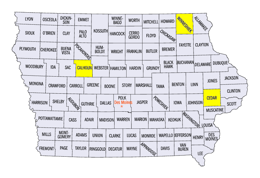
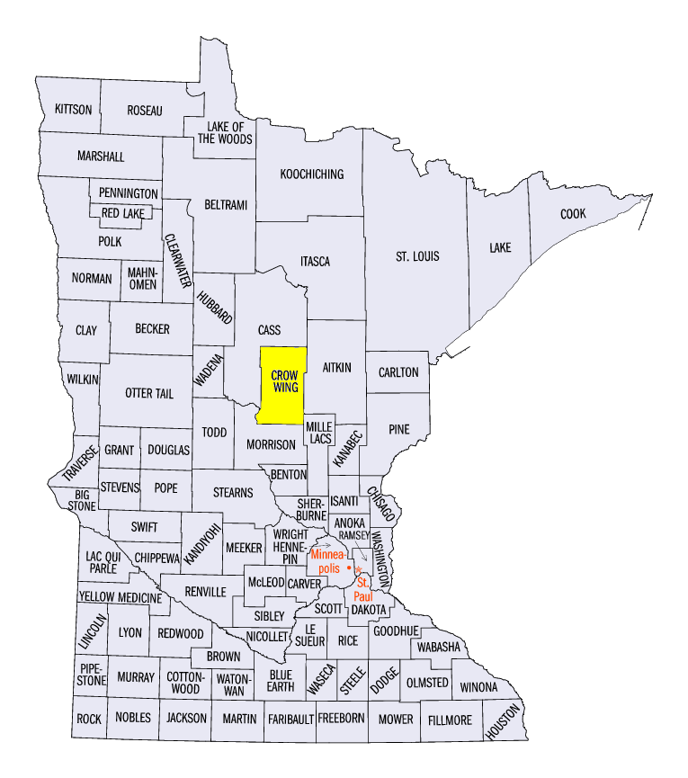
(Figure 21). Heavier amounts in Wisconsin included 21.3 inches near Sturgeon Bay (Door County), 21.0 inches near Belgium (Ozaukee County), and 19.1 inches in Green Bay (Brown County). In Michigan, amounts included 43.5 inches near Wellston (Manistee County), 38.6 inches in Petoskey (Emmet County), and 37.6 inches near Greenland (Ontonagon County). Notable amounts in Iowa and Minnesota were 18.8 inches in Lowden, IA (Cedar County), 18.3 inches in Calmar, IA (Winneshiek County), and 12.3 inches in Pine River Dam, MN (Crow Wing County). The heavy snow throughout the period broke more than 250 daily snowfall records across the region (Figure 22).
Deep Chill throughout the Week
Very cold temperatures during the week, including an Arctic outbreak, led to below-normal temperatures across the entire Midwest (Figure 23). The coldest areas were in Iowa, northern Illinois, Wisconsin and Minnesota, where average temperatures were 15-20°F below normal. The Ohio River Valley was 4-7°F below normal by comparison. More than 200 daily low maximum and low minimum temperature records were broken prior to the Arctic outbreak, with more than 1,350 records broken or tied in total from January 22-31 (Figure 24).
Moderate to Heavy Precipitation
Snowstorms and moderate rain in the Ohio River Valley contributed to most of the precipitation in the Midwest during the period (Figure 25). Most of this precipitation fell in the eastern half of the region, with areas in Illinois and Indiana also receiving amounts of more than an inch. Amounts in southern Wisconsin, eastern Iowa and Minnesota were also significant, as these areas had one and a half to two times the normal amount (Figure 26). Only a few areas of western Iowa and southwestern Missouri were significantly drier than normal. Parts of west-central Iowa had less than a quarter of the normal amount.
-BJP-