December 22-31, 2020
Midwest Weekly Highlights - December 22-31, 2020
Slightly Warmer
Temperatures were slightly warmer than normal across the Midwest
(Figure 1). Many areas in the region were 1-3°F above normal. A few areas were near normal with some areas of northern Minnesota slightly below normal. No strong variations from normal were observed, with only parts of Lower Michigan more than 3°F above normal.
Wet in the West
Precipitation in the western half of the Midwest was common during the period, especially in southern Iowa and Minnesota (Figure 2). Amounts of over an inch were common in northern Missouri and southern Iowa, as well as the U.P. of Michigan and the Ohio River Valley. However, these amounts were more than twice the normal amount for only northwestern Missouri, southern Iowa and most of Minnesota
(Figure 3). A slot of drier weather was observed from central Missouri through western Ohio, with spotty areas in central Illinois and northwestern Ohio receiving less than half the normal amount. More than 100 daily precipitation records were broken during the period (Figure 4).
Major Snow Events December 23-25 & December 29-30
Two powerful winter storms brought heavy snowfall to the northern half of the region during the period. The first of these storms impacted Minnesota, northwestern Iowa, northwestern Wisconsin lake-effected areas along the Great Lakes from December 23-25. The main heavy snow event occurred on December 23 through the morning of December 24 (Figure 5). Areas in east-central Minnesota, extreme northern Wisconsin and the western U.P. of Michigan received more than six inches of snowfall, with heavier amounts over eight inches reported. As the storm moved east, lake-effect snow was common along the eastern shores of Lake Michigan and Lake Superior through the morning of December 25 (Figure 6). Another storm impacting the east coast of the U.S. brought moderate to heavy snow to eastern Kentucky and eastern Ohio as well, with lake-enhanced snowfall amounts over 10 inches in northeastern Ohio. Lake-effect snowfall continued through the day on December 25 before finally dissipating by the morning of December 26 (Figure 7).
After moderate snowfall impacted Wisconsin throught the morning of December 28 (Figure 8), the second major storm during the period brought heavy snow across the entire northern half of the region on December 29 through the morning of December 30 (Figure 9). Large areas in Minnesota, Iowa, Wisconsin and Michigan had 4-6 inches of snowfall, with a band of snow in east-central Iowa through northwestern Illinois recording 8-10 inches. Locally heavy amounts over a foot were also reported. Unlike the previous storm, lake-effect snow was spotty after the main snowfall event in the Great Lakes, however (Figure 10).
In total, snowfall in lake-effect areas of Michigan and northeastern Ohio were over a foot in most cases, with more than ten inches falling across central Minnesota, east-central Iowa and northwestern Illinois
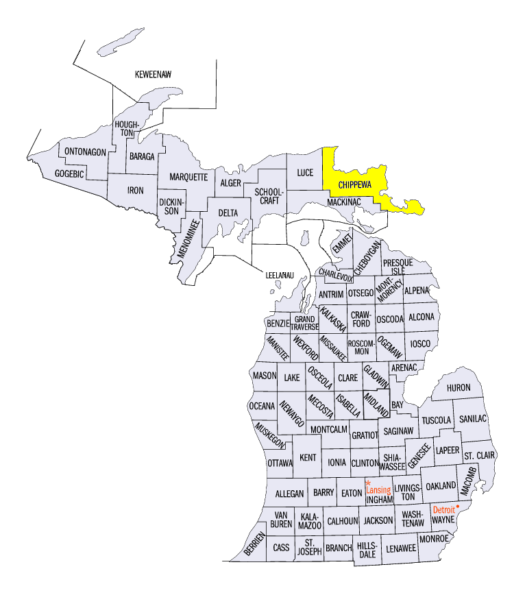
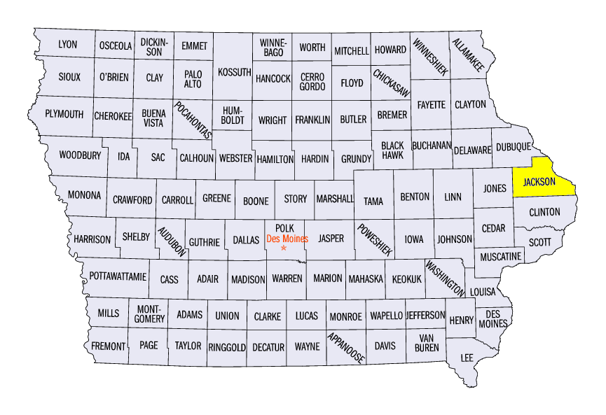
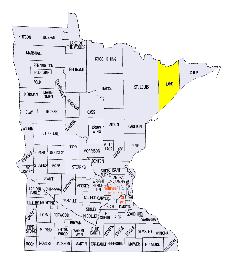
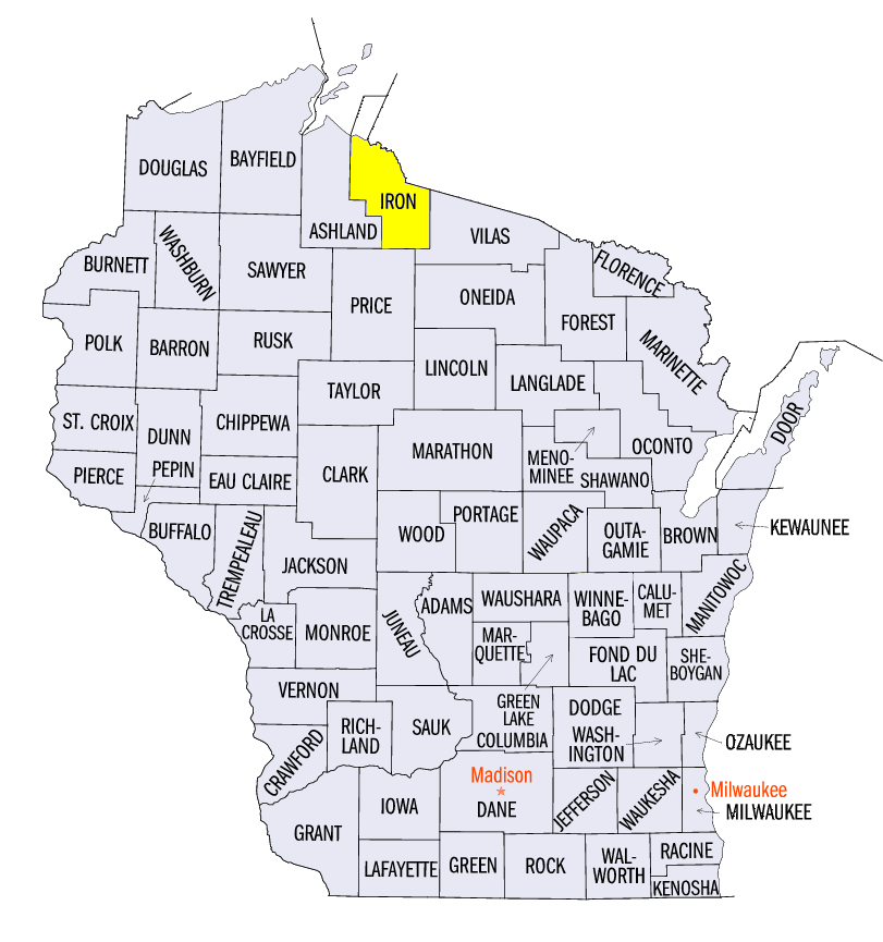
(Figure 11). Some of the heaviest amounts recorded for the period in the affected states included 31.9 inches in Tahquamenon Falls, MI (Chippewa County), 14.0 inches near Bellevue, IA (Jackson County), 17.6 inches in Two Harbors, MN (Lake County), 21.4 inches in Chardon, OH (Geauga County) and 23.0 inches in Hurley, WI (Iron County). More than 150 daily snowfall records were broken across the region during the period (Figure 12).
Drought Increases Slightly to End 2020
Precipitation continued to elude areas from northern Missouri through northern Indiana during the last week of 2020, leading to a slight increase in drought according to the December 31 U.S. Drought Monitor
(Figure 13). Most of the increase in coverage was in northeastern Missouri, where several more counties were classified in moderate drought. The Midwest finished 2020 with slightly more than 12 percent of the region in drought, with an estimated 3.2 Million people living in drought-affected areas.
-BJP-