August 1-10, 2020
Midwest Weekly Highlights - August 1-10, 2020
August 10 Midwest Derecho
A sustained line of storms during the day of August 10 called a derecho caused millions of dollars in damage from Iowa through western Ohio (Figure 1). The storm formed in eastern Nebraska and South Dakota shortly after sunrise and continued east through Iowa (Figure 2). A prominent bow-echo formed on radar in central Iowa, where the storm caused some of its most intense damage. Across the nine-state Midwest region, 695 reports of wind damage, hail and tornadoes were reported from the storm and other storms on August 10. In total, more than 1 million people were without power at one point after the storm with at least 60 injuries and 4 deaths. One of these deaths was outside of the derecho in Pevely, MO when a woman was struck attempting to move her vehicle.
Iowa Impacts
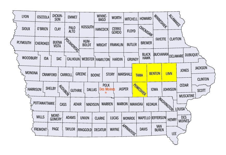
Iowa was the hardest hit state from the derecho, as more than 5 million acres of corn and soybeans were flattened. Satellite imagery showed the extent of the damage in central Iowa the next day
(Figure 3). Wind gusts along the bowing line were frequently recorded at 70-80 mph. Some of the strongest recorded gusts included 90 mph in Blairstown, IA (Benton County) and near Chelsea, IA (Tama County), 100 mph in Hiawatha, IA (Linn County) and a staggering 112 mph near Midway IA (Linn County). Damage to structures, trees, roofs, and buildings was pervasive. Large grain silos and elevators were toppled. Deaths were recorded in Iowa from a bike rider in Cedar Rapids (Linn County) who was struck by a tree, an electricution from a downed power line in Brooklyn, IA (Poweshiek County) and tree through a house near Malcolm, IA (Poweshiek County). At its height, more than 550,000 Iowans were without power, with outages expected to last several days due to the expansive amount of damage. At least 13 counties had been declared disaster areas.
Illinois/Southern Wisconsin Impacts
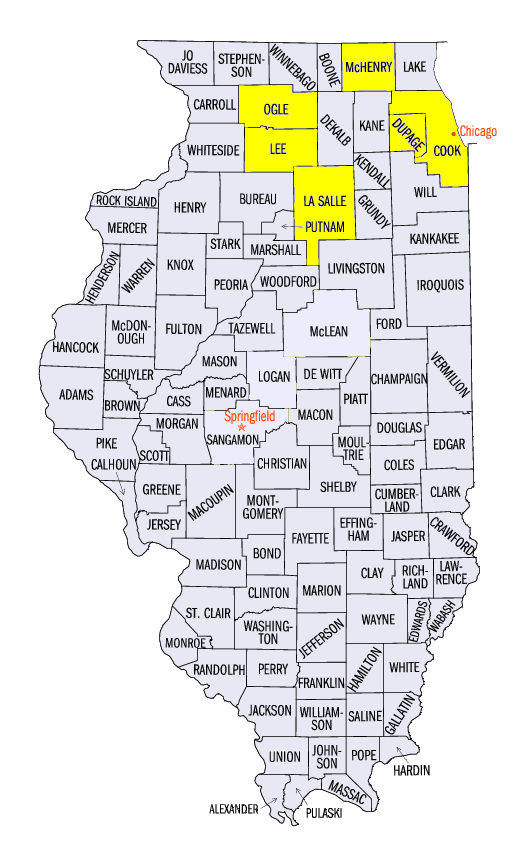
Strong winds from the derecho continued across the Mississippi River into southern Wisconsin and northern Illinois. This included several tornadoes. Including EF-1 tornadoes near Machesney Park, IL (Winnebago County), Marengo, IL (McHenry County), Wheaton, IL (Dupage County), and the West Ridge neighborhood of Chicago (Cook County). Winds gusts of 70 mph were common along the storm’s path, including gusts of 92 mph near Dixon, IL (Lee County), 91 mph near Cedar Point, IL (LaSalle County), and 85 mph at Lincoln Square in Chicago. Five injuries were reported in Forreston, IL (Ogle County) as a trailer park was destroyed from the winds. Another injury was reported near Peru, IL (La Salle County) from a truck driver. More than 800,000 customers were without power at one point as the Chicago suburbs were strongly affected. More than 100,000 were without power for several days after the storm. Several thousand were also without power in southern Wisconsin.
Indiana/Ohio/Michigan Impacts
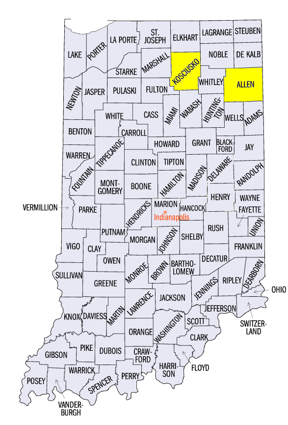
As the derecho moved into Indiana, the expanse of the storm widened throughout most of Indiana and into parts of southwestern Michigan. Wind gusts of 60-65 mph were common as the storm finally began to lose some strength. However, two tornadoes were reported, including an EF-1 tornado near North Webster, IN (Kosciusko County). A mobile home structural failure trapped a woman and a child near Wallen, IN (Allen County). The woman later died in the hospital. Several storm reports were registered in extreme western Ohio before the storm finally began to dissipate. More than 100,000 customers in Michigan and Indiana combined were without power at one point after the storm, with thousands without power several days later.
Mild Temperatures
A blocking pattern caused by Hurricane Isaias along the east coast kept a cool Canadian high pressure system locked over the Midwest during the first ten days of August (Figure 4). Most of the region was 1-3°F below normal, with some Missouri and southern Illinois 3-5°F below normal. A few areas in eastern Ohio and eastern Kentucky were near normal, along with pockets of northern Minnesota and the U.P. of Michigan.
Limited Precipitation
Prior to the derecho, only a few areas in the Upper Midwest and Ohio River Valley had significant precipitation during the first ten days of June
(Figure 5). Amounts over 3 inches fell around the St. Louis, MO area as well, which was more than three times the normal amount (Figure 6). Northern Minnesota and scattered areas of Michigan also received 2-3 inches of rainfall, which was well above normal. Severe storms also occurred on August 9 in the Upper Midwest
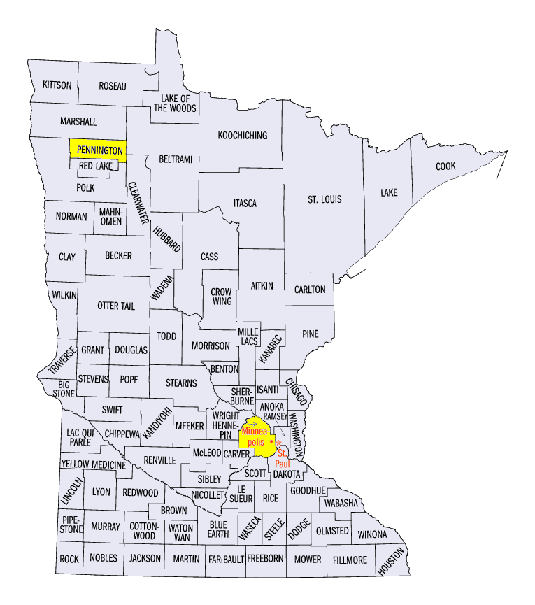
(Figure 7), leading to large hail and several weak tornadoes. A 2.5 inch diameter hailstone was recorded near Loretto, MN (Hennepin County) and a 77 mph wind gust was reported near Thief River Falls, MN (Pennington County). Extremely dry conditions continued in Iowa, with areas of eastern Iowa and northern Illinois receiving less than half the normal amount.
Drought Worsens in Western Iowa
Extreme Drought was introduced into west-central Iowa according to the August 4 U.S. Drought Monitor (Figure 8). Soil conditions continued to worsen in these areas as drier weather continued. While some rain fell during the August 10 derecho in these areas, winds led to the demise of some of these crops. Meanwhile, drought coverage improved overall across the full region, with cooler temperatures and plentiful rainfall in Indiana, Ohio and Missouri. Drought was eliminated from Indiana and was halved in Ohio.
-BJP-