August 2020
Monthly Overview - August 2020
Scattered Rainfall
Precipitation was scattered across the Midwest, with the central Midwest very dry and areas in the Upper Midwest and Ohio River Valley wet
(Figure 1). Regionwide precipitation was 3.20 inches which was 0.45 inches below normal. Most of Iowa, northern Illinois and northern Missouri had less than half the normal amount for the month (Figure 2), with southern Iowa and northwestern Illinois receiving less than a quarter of normal. Statewide, Iowa had its 3rd driest August on record (1895-2020) while Illinois had its 13th driest on record (1895-2020). Climate Division 7 for southwestern Iowa had its driest August on record (1895-2020) with just 0.74 inches of precipitation. Meanwhile, areas in Minnesota, the U.P. of Michigan and Kentucky were wet in August. Some areas of western Kentucky and northern Minnesota had more than 175 percent of normal. More than 275 daily records were broken across the region during the month
(Figure 3).
Variable Temperatures
Temperatures across the Midwest were variable, with some areas slight above and others slightly below normal (Figure 4). Temperatures for the region were 71.3°F which was 0.4°F above normal. Scattered areas of the Upper Midwest were slightly above normal, while most of Missouri, southern Illinois and areas of western Kentucky and southwestern Indiana were slightly below normal. A cool period began the month as Canadian high pressure moved into the region, with heat returning in the second half of the month. More than 290 high
(Figure 5) and 310 low (Figure 6) temperature records were scattered across the region from the extremes during each half of the month.
August 10 Derecho
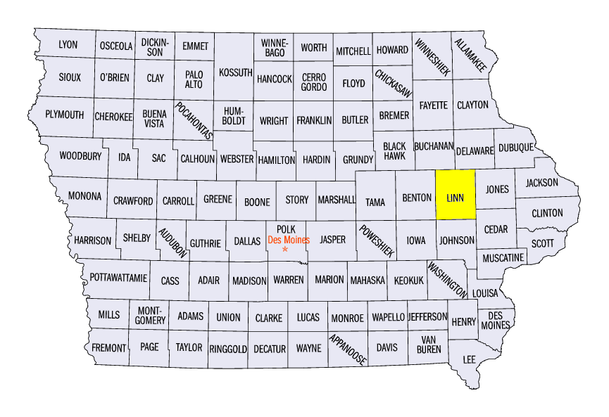
On August 10, a sustained line of thunderstorms known as a derecho impacted areas from Iowa through Ohio (Figure 7), causing millions of dollars in damage. Forming in eastern Nebraska and southern South Dakota during the early morning hours, the derecho tore a path through central Iowa in the mid- to late morning. Significant damage to structures, trees and cropland were sustained, with more than an estimated five million acres of corn and soybeans flattened. Wind gusts along the derecho frequently reached 70-80 mph, higher gusts recorded above 90 mph. A 100-mph gust was reported in Hiawatha, IA (Linn County), and a 112-mph wind gust was reported near Midway, IA (Linn County). Some of the worst damage to structures occurred in Linn County, where Cedar Rapids, IA is located. A bike rider was struck by a tree in Cedar Rapids, leading to a fatality. Several days after the event, more than 100,000 people were still without power in the Cedar Rapids area, and tens of thousands were without power for more than a week, as many local and regional utility crews were dispatched to the east coast for Hurricane Isaias recovery. An estimated 90 percent of structures in Cedar Rapids sustained some sort of damage from the storm, and more than 1,000 homes were destroyed.
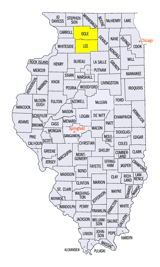
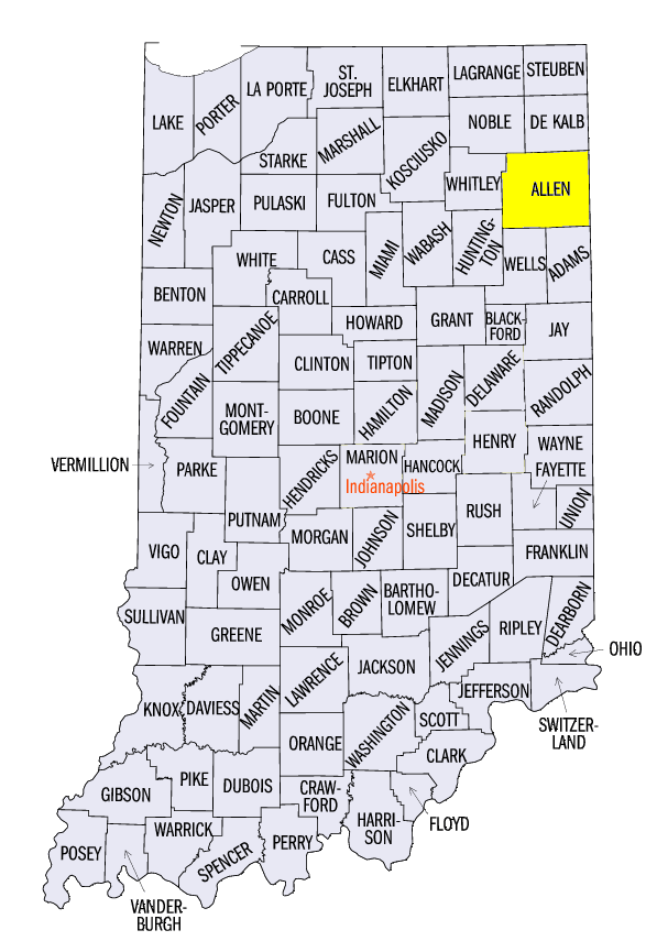
Further east, impacts continued in northern Illinois and southern Wisconsin, with several EF-1 tornadoes reported in the Chicago metro area. Wind gusts remained over 70 mph along the storm’s path, with a 92-mph gust near Dixon, IL (Lee County). At least six injuries were reported in Illinois, which included five from the destruction of a trailer park near Forreston, IL (Ogle County). More than 800,000 people were without power at one point in the Chicago area, with more than 100,000 without power for several days. As the derecho moved into Indiana and Lower Michigan, winds slowly began to weaken, as gusts were reported between 60-65 mph. Several tornadoes were reported as well. A woman and child were trapped in a mobile home near Wallen, IN (Allen County) from the storm, with the woman later dying in the hospital. More than 100,000 customers were without power in Michigan and Indiana after the storm, while thousands more waited several days for power to return. As storm finally began to dissipate, isolated gusts caused damage in western Ohio. In total, 695 severe weather reports were recorded in the Midwest from the derecho and other scattered severe weather on August 10 (Figure 8), resulting in at least 60 injuries and 4 deaths.
Drought Worsens
Extremely dry conditions in August worsened drought in Iowa according to the U.S. Drought Monitor
(Figure 9). Extreme drought was introduced in west-central Iowa at the beginning of the month (Figure 10), with areas of moderate and severe drought expanding during the month. By the end of the month, more than 60 percent of the state was in drought
(Figure 11), with more than 95 percent either abnormally dry or in drought. Dry conditions during the month also led to abnormally dry weather in northern Illinois. Many of these areas had less than half the normal amount of precipitation during the month, with warmer than normal temperatures during the second half of the month.
Crop Conditons Decline
Crop conditions severely declined in August across Iowa and the Corn Belt from the effects of drought and the August 10 derecho. Corn and soybeans in western Iowa were already stressed from extreme drought before severe winds led to the flattening of millions of acres of crops. Advanced metrics tracking corn conditions in Iowa and across the U.S. indicated a sharp decline from late July through August. As of the August 31 USDA NASS Crop Progress Report, 25 percent of Iowa corn was rated poor to very poor while only 19 percent of the states topsoil moisture was rated as adequate.
Severe Weather
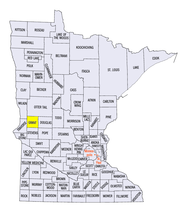
Severe weather outside of the August 10 derecho was common during the month. More than 1,200 reports of strong winds, hail and tornadoes were reported in August, with more than 500 on days other than August 10. Prior to the derecho, severe storms impacted Minnesota and Wisconsin from August 7-9. Strong winds and several brief tornadoes were reported, with the western suburbs of the Twin Cities receiving 2-inch diameter hail on August 9 (Figure 12). On August 14, an outbreak in Minnesota led to more than 80 reports, with five tornadoes reported in Grant County, MN alone. Strong winds led to a grain bin collapse near Felton, MN while many trees and power lines were felled. Rounds of severe thunderstorms also impacted Ohio from August 25-28.
-BJP-