June 2020
Monthly Overview - June 2020
Scattered Thunderstorms
Thunderstorms were scattered across the region in June, leaving some areas of the Midwest very wet and others dry
(Figure 1). Regionwide precipitation was 3.90 inches which was 0.34 inches below normal, or 92 percent of normal. Some of the wettest areas were in eastern Iowa, southeastern and northwestern Minnesota, western Wisconsin and western Kentucky. Some of these areas received more than 150 percent of normal (Figure 2). On the other end, southwestern Missouri southwestern Iowa and areas around Duluth, MN received less than half the normal amount for June. Significant rainfall events impacted the region, including the remnants of Tropical Storm Cristobal on June 8-10
(Figure 3), and an event from June 28-30 that led to flooding (Figure 4). In total, more than 340 daily precipitation records were recorded
in June (Figure 5).
Summer Heat
Warmer temperatures prevailed across most of the Midwest in June (Figure 6). Average temperatures for the region were 70.7°F which was 2.1°F above normal. Areas in western Iowa, southwestern Minnesota and northwestern Missouri were the warmest. Meanwhile, most of Kentucky was near normal for June. Very hot temperatures were widespread before the remnants of Tropical Storm Cristobal impacted the region and led to cooler conditions into mid-June. Temperatures were moderately warmer than normal throughout the second half of the month. In total, more than 600 daily high maximum and minimum temperature records were broken across the region in June
(Figure 7).
Tropical Storm Cristobal Tracks Through Midwest
The remnants of Tropical Storm Cristobal impacted the Midwest from June 8-10 (Figure 8). The storm was one of the furthest west-tracking tropical storms for the region in recorded history. Cristobal was only the 2nd storm to track through Iowa and only the third to track through on-shore Wisconsin. The remnants of Hurricane Gilbert in 1988 tracked across maritime southeast Wisconsin. The storm impacted all nine states in the region with a mixture of heavy rain, strong winds and severe weather. Most of the heavy rain
(Figure 9) and non-thunderstorm winds (Figure 10) were recorded on May 9 through Iowa, Wisconsin, Illinois and western Indiana. Wind gusts over 50 mph were common, with both Chicago, IL airports recording wind gusts of 60+ mph. More than 80 daily precipitation records were broken as well
(Figure 11). On June 10, severe thunderstorms impacted the eastern third of the region (Figure 12). Lower Michigan, northeastern Indiana, Ohio and eastern Kentucky had widespread thunderstorm wind damage, with gusts over 60 mph. Several reports of 2-inch hail were also reported.
Drought Introduced into the Region
Drought was introduced in the Midwest on June 2 for the first time in 29 weeks according to the U.S. Drought Monitor
(Figure 13). The streak of drought-free conditions in the region was the 2nd longest in the history of the U.S. Drought Monitor (2000-2020), with the longest lasting 32 weeks from January 1-August 6, 2019. In June, moderate drought expanded across portions of west-central and northeastern Minnesota, where limited rainfall and increased evapotranspiration were contributing factors. Meanwhile, warmer temperatures and limited rainfall led to an expansion of abnormally dry conditions across Indiana and portions of Illinois, Iowa and western Missouri. As of the June 30 U.S. Drought Monitor, only slightly more than 3 percent of the Midwest was in moderate drought (Figure 14), but nearly a quarter of the region was considered abnormally dry.
Severe Weather Increases
Severe weather increased in June across the Midwest. More than 1400 reports of strong winds, hail and tornadoes were reported in the regions’ climatologically most active month. This compared to more than 1800 reports in June 2019. Most of these reports were from strong thunderstorm winds with more than 80 reports of strong winds over 75 mph. There were also 18 reports of hail over 2.0 inches in diameter. However, tornadoes in the Midwest have been significantly lower through June 2020, with only 176 reports and only 24 in June. In 2019 there were 348 reports through June and 186 reports through June 2018.
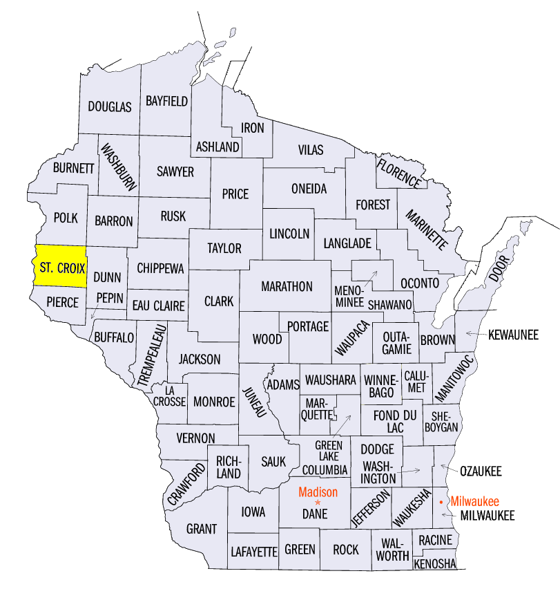
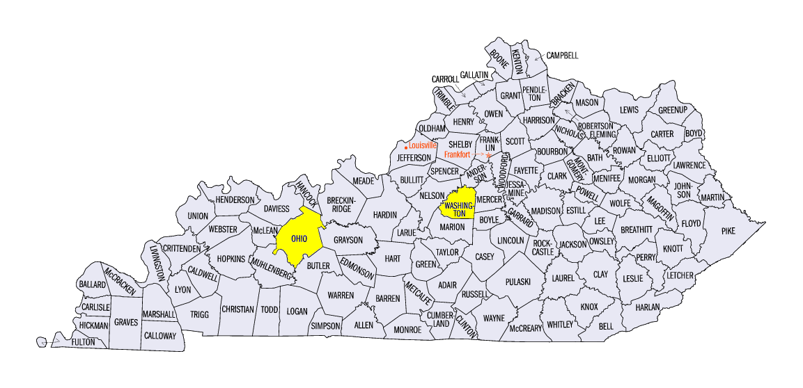
Flash Flooding June 28-30
Significant rainfall from June 28-30 led to flooding and flash flooding in southeastern Minnesota, western Wisconsin, and southwestern Kentucky. Extreme flooding near Baldwin, Wisconsin (St. Croix County) occurred on June 28, where radar-estimated amounts of rain were up to 9 inches. At least eight households were evacuated with five motorists rescued from flooding and one fatality from driving over a water-covered road. In Kentucky, two people were rescued from their vehicle in high water near Willisburg (Washington County), with a man later perishing in the hospital. A voluntary evacuation was also ordered from flooding near Beaver Dam, KY (Ohio County).
-BJP-
The Illinois State Climatologist Office also contributed to this report.
The Indiana State Climate Office also contributed to this report.
The Iowa Climatology Bureau also contributed to this report.
The Kentucky Climate Center also contributed to this report.
The Michigan State Climatologist Office also contributed to this report.
The Minnesota State Climatology Office also contributed to this report.
The Missouri Climate Center also contributed to this report.
The State Climatology Office for Ohio also contributed to this report.
The Wisconsin State Climatology Office also contributed to this report.