April 22-30, 2020
Midwest Weekly Highlights - April 22-30, 2020
Cold Slowly Recedes
After a bitter cold third week of April, warmer weather began to creep into the western Midwest during the final week of April
(Figure 1). Most of Iowa, Minnesota and northwestern Missouri had temperatures 1-3°F above normal. However, temperatures across the Great Lakes and Ohio River Valley remained below normal. Michigan was one of the coldest areas at 4-6°F below normal. While minimum temperatures averaged below freezing in the northern Great Lakes (Figure 2), maximum temperatures had the greatest differences from normal
(Figure 3). Areas in the U.P. of Michigan and northern Wisconsin were as much as 8°F below normal. In contrast, maximum temperatures in western Iowa and southwestern Minnesota were 5-7°F above normal. However, temperature records were mostly from colder temperatures, with more than 110 daily low maximum and minimum temperature records broken across the region (Figure 4).
Heavy Rain in Illinois and southern Missouri
Rounds of storms that affected the southern Midwest and Michigan dumped three or more inches of rain across most of Illinois and southern Missouri during the week
(Figure 5). In many cases, this translated to two to three times the normal amount (Figure 6). At least three separate storms traversed the region during the period, with widespread areas of 1+ inches of rain falling on at least five different days in the region. These dates were through the mornings of April 23
(Figure 7), April 25 (Figure 8), April 26
(Figure 9), April 29 (Figure 10) and April 30
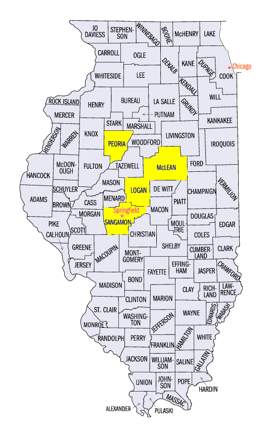
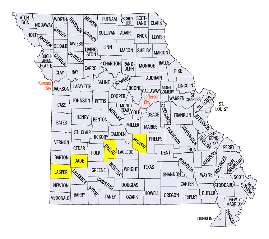
(Figure 11). Some of the heaviest totals in Illinois included 6.82 inches in Mount Pulaski (Logan County), 6.79 inches near Bloomington (McLean County), 6.69 inches near Springfield (Sangamon County) and 6.17 inches near Lincoln (Logan County). In Missouri, values included 5.44 inches near Waynesville (Pulaski County), 4.99 inches near Buffalo (Dallas County) and 4.86 inches in Lockwood (Dade County). Of the more than 150 daily precipitation records broken during the period (Figure 12), 45 were broken in Illinois and 25 in Missouri.
Flooding Receded on Mississippi, Rises on the Illinois
While drier weather allowed minor flooding to recede along the Mississippi River during the week, heavy rain in Illinois introduced flooding along the Illinois River
(Figure 13). While heavy rain occurred throughout the period, storms through the mornings of April 29 and April 30 caused many tributaries in the Chicago area to reach minor flood stage. Moderate flood stage also observed downstream of Peoria, IL (Peoria County).
Planting Season Ramps Up
With forecasts calling for heavy rainfall in the final days of April in the southern Midwest, farmers were motivated to plant across the Midwest according USDA NASS for the week ending April 26. Kentucky led the way with 44 percent of corn planted (Figure 14), with Minnesota at 40 percent and Iowa at 39 percent. These states were all 17 or more percent ahead of the five-year average. The only state significantly behind with corn planting was Missouri, which was 21 percent behind the five-year average. Early soybeans were also planted across Illinois and Kentucky
(Figure 15), where 18 percent were planted. Indiana and Iowa were at 11 and 9 percent respectively. Decreases in soil moisture throughout April led to favorable conditions for planting ahead of the heavy rain in final days of April.
Missouri Severe Weather
Rounds of storms led to severe weather across southern Missouri during the week (Figure 16). Most of this severe weather occurred on April 28
(Figure 17). Dozens of wind reports were relayed of damage to large trees, outbuildings and power lines. A wind gust of 75 mph was recorded near Jasper, MO (Jasper County). On April 24, a weak landspout tornado was also reported in northern Missouri, as well as in southwestern Indiana on April 25. No damage was reported with either tornado.
-BJP-