The Great Flood of 1913
100 Years Later

Weather Prior to the Flood
Introduction
The torrential rains from March 23-27th over the Ohio Valley produced a flood of rare magnitude and destructive force. The Ohio Valley was no stranger to flooding, with floods occurring on a nearly regular basis, especially in spring. Despite the frequency of flooding, this event was unprecedented in how and where the rain fell, its duration, and the severity of the damage in its wake. Levees and dams failed under the immense pressure of so much water. In the matter of a few days a quarter of a million people were homeless across a multistate region, and more than 500 people perished.
Before the Flood: The Ohio Valley Winter of 1913
The eastern United States in December of 1912 and January, February, and March of 1913 was very mild with temperatures averaging five degrees above normal. The opposite occurred over the central and western half of the country as a trough of low pressure became predominant over the Rockies while an area of high pressure lingered over the western Atlantic Ocean. The resulting winter for the Ohio Valley was warm and wet as storm systems out of the Rockies made their way northeast and over the nation’s midsection. Record rains were recorded in many parts of the eastern U.S. in January and again in March as a result.
Another glaring difference between this winter and normal winters was the lack of significant snow events. Most of the storm systems produced rain, or in some instances freezing rain, as opposed to snow. The northern extremes of New York, Pennsylvania, and New England had snowfall deficits two to three feet below normal for the winter. In Ohio the above normal temperatures kept Lake Erie from freezing over that winter, and the lack of icing on the lake allowed for enhanced lake effect snow, so seasonal snowfall was a little above normal over northern lakeshore regions. The mild winter temperatures allowed for several thaws, so it was difficult to preserve a snowpack other than in far northern counties. Another important outcome of the warmer temperatures was that the ground was not frozen in late March, a factor that would have increased runoff resulting in worse flooding than what was actually observed.
^TOP
January 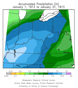
January of 1913 was notably warm across the eastern half of the country as the result of an area of high pressure locked over the western Atlantic Ocean. This supported a flow pattern that brought warm air from the Gulf of Mexico northeastward. The resulting weather that month was predominantly cloudy, rainy, and warm over the Ohio Valley and most of the east coast. The heavy rain was primarily in the Ohio and Tennessee Valleys through the first half of the month, which then moved to the east coast for the later part of the month.
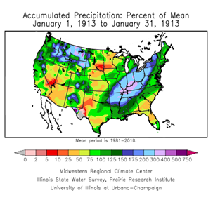
The precipitation during January of 1913 was unusually high; it was the wettest January to date for many parts of the Ohio Valley. Over Kentucky, western Tennessee, and southern Indiana rainfall totals ranged from 8 to 10 inches above normal for the month. The rest of the Ohio Valley received rainfall 2 to 6 inches above normal for the month. Precipitation for the eastern U.S. was notable, but most especially in the southern Ohio basin. From Arkansas to New York, rainfall averaged 4 to 6 inches or 150-200 percent of normal, while over Kentucky the average rainfall was 11 inches, which is 300-400 percent of normal. As a result, the Ohio River experienced destructive floods primarily south of the state of Ohio like in March 1997. In Kentucky the lower Green River Valley and the lower Cumberland and Tennessee Rivers saw the worst flood damage.
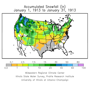
Temperatures were uncharacteristically warm in January, with average temperatures averaging 6 to 10 degrees above normal (1981-2010 normals). These warm temperatures supported the precipitation in the form of rain and less than normal snowfall.
Flooding in January was frequent across most of the region, however the floodwaters were fairly contained and the damage was limited north of the Ohio River. The fact that the flooding was not more severe was due primarily to the fact that the ground was not frozen and the runoff was therefore not as rapid as it could have been in a typical January. Another factor that helped limit the flood severity was the lack of snowpack, which can add a substantial amount of runoff.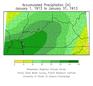 The flood waters of the Ohio River often cause the Mississippi River to flood, however when the flood crest arrived from the Ohio River the Mississippi River was at a low stage.
In Kentucky, where rainfall was the heaviest, the flooding was exceptional. Destructive floods occurred across rivers and streams, large and small, most notably in the Green River Valley. The entire Kentucky River basin was flooded, with relief measures by the Red Cross initiated to aid the flood victims. The Ohio River flooded very little in Ohio and Indiana, but in Louisville, Kentucky the flooding was significant. Over 1,700 families were made homeless and a large section of the city was inundated on the 13th of January. In the Green River Valley between 2,000-3,000 houses were inundated with the river cresting and remaining high for a week. The Weather Bureau’s assessment of the damages for the floods of January 1913 was estimated at just over $2 million. (Walz, F.J., Louisville KY Weather Bureau, Monthly Weather Review, page 29)
^TOP
February
As cloudy, wet, and warm as January was, February was sunny, cold, and dry. The only similarity between the two months was the lack of snowstorms. A strong area of high pressure built over the central part of the country, which slid over the 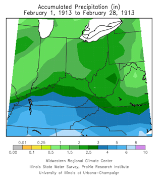 eastern seaboard by mid month. Temperatures for the first half of the month were below normal, though not exceptionally so. For the second half of the month the temperatures were slightly above normal. The last week of the month saw a period of heavy rain, but the monthly total rainfall amounts were below normal. The rainfall over the Ohio Valley averaged around 2 inches, with even less in north central Indiana. Snowfall for the region was near normal, however, the warmer temperatures in the later half of the month meant only northern sections of Ohio, Indiana, New York, and Pennsylvania had snow on the ground going into March. In general the flood damage in February was relatively small.
March
The powerful storm systems that tore across the central and eastern U.S. in late March of 1913 left more than a thousand people dead and over a quarter million homeless. Strong areas of low pressure produced tornadoes in no less than a dozen states in the plains and the south, ice storms in Illinois and New York, storm force winds across the Midwest and Great Lakes, and most notably a vast area of unprecedented floods.
Typical for March, the temperatures wavered between warm and cold, though the average temperatures for the month were slightly above average. The first week was unseasonably cold with two notable cold spells on the 1st and 2nd and again on the 6th and 7th. For most of the region the coldest day in the month occurred on the 7th with Garrettsville Ohio reporting a low of -8F. Temperatures were recorded below zero at all reporting sites north of the Ohio River including western Pennsylvania and West Virginia.
Apocalyptic floods, destructive winds, killer tornadoes, and hurricane force winds all occurred across the Midwest and eastern U.S. in the month of March. Over the Ohio Valley and many parts of New England, March 1913 shattered the record-books for monthly precipitation, mainly a result of the heavy rains later in the month. More detail is provided on the rain from the 23rd through the 27th in the next section, The Storms of March 23-27. With the ground thawed and the majority of the snow cover melted in the Ohio Valley, there were not any indications that could have prepared the region for unprecedented floods.