The Great Flood of 1913
100 Years Later

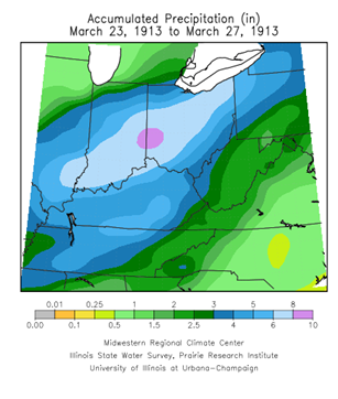
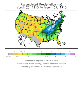
The Storms of March 23-27, 1913
March 13-15 Storms
It was on the 13th that a deep area of low pressure moved out of the Rockies and into Texas and then into Kansas that afternoon. At this time strong southerly winds were developing across the Midwest and northwest winds over the northern plains. These strong southerly winds pulled warm and moist Gulf air northward into the Ohio Valley where temperatures were in the 60s, 70s, and 80s, setting many records for that early in the year. Meanwhile in South Dakota and Nebraska temperatures had fallen 20-30 degrees with heavy snow and sleet in Illinois.
Strong southerly gale force winds were observed across most of the Ohio Valley. A series of violent thunderstorms occurred with this storm system, generally south of the Ohio Valley. Records show that during this time a number of devastating tornadic storms formed over the Gulf and southeast states of Arkansas, Tennessee, Alabama, Georgia, and Louisiana between the 13th and the 15th. High winds also occurred with the larger storm system with widespread inland gale force winds with gusts around 60mph observed at Louisville, Kentucky on the 14th. Significant damage was caused by the wind, with numerous power poles and trees down across the region.
The third week of March was dominated by waves of low pressure, resulting in large fluctuations in temperatures ranging all the way from 18°F to 85°F over the Valley. Prior to the period of the 23rd through the 27th, the rainfall during March had been near normal over the Ohio Valley. Conditions were dry during the two cold spells, but rain did precede them with only light rain on the 14th and heavier rain on the 20th-21st. Other than far northern areas, mainly in the Great Lakes Basin, there was no snowfall in the region. What snowfall had been around was able to melt during the second week heat wave.
^TOP
March 20-21 Storms
On the 19th a more powerful storm system than that on the 13th moved out of Pacific Northwest and tracked eastward. On the 20th it was centered over Lake Michigan producing strong winds and snow. Another area of low pressure over Arkansas generated a series of significant tornadoes over the Gulf States the afternoon of the 20th.
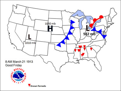 The primary surface low intensified while centered over western Lower Michigan on the morning of the 21st as it merged with the surface low from Arkansas. Over the Midwest and Lakes Region during this time winds were sustained at tropical storm force magnitude, and upwards of hurricane force along the Great Lakes. The Weather Bureau Office in Detroit reported, “A gale of unprecedented severity swept over southern Michigan. Buildings were razed, roofs blown off, chimneys toppled over, signs blown down, trees broken and uprooted, overhead wires prostrated, and several lives lost as a result of the storm’s fury.” (Detroit Weather Bureau records)
By the night of the 21st the low pressure system had merged with another low coming up the east coast over Quebec, producing strong storms and winds from Cape Hatteras North Carolina to Maine. At most of the Weather Bureau Offices along the Great Lakes, the strength and duration of the winds in this event exceeded those in the historic Great Lakes Hurricane, which would occur later that year in November. The precipitation that fell with these storms averaged a half to one inch of rain, which was insufficient to produce flooding yet it saturated the ground, setting the stage for the floods to come.
This storm, the storm on the 23rd and the following flood completely paralyzed all railroad, telegraph and telephone systems in Indiana, Ohio and Illinois.
^TOP
Saturday, March 22nd
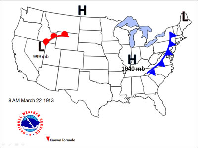 By the 22nd strong high pressure had slid out of the Canadian Northwest rushing cold air into the region. Temperatures dropped below freezing on that Saturday and Saturday Night. This high-pressure area blocked the next incoming storm system which became locked over Nevada for about 12 hours. The high eventually slid off the eastern seaboard and away from the Ohio Valley on the morning of the 23rd.
Easter Sunday, March 23rd
By the morning of Easter Sunday, March 23rd the low responsible for the Great Flood was over Colorado. Temperatures at this time across the upper plains were in the 30s with light rain over western sections. Southerly winds ahead of the low-pressure system brought in warm moist air to the Ohio Valley. There temperatures rose from the 30s in the morning to the lower 70s by late day.
The Weather Bureau weekly forecast issued that Sunday refers to the incoming storm: “The distribution of barometric pressure over the Northern Hemisphere is such as to indicate a continuance of abnormal storm activity and marked fluctuations in temperature in the United States the coming week. The storm central Sunday of the Rocky Mountain region will move rapidly northeast, accompanied by shifting gales.” (Henry J. Cox, Weather Bureau)
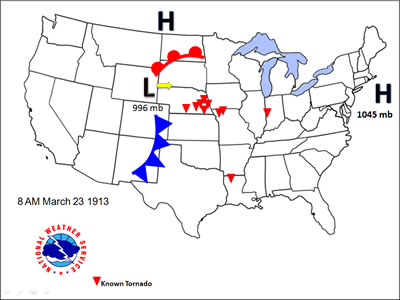 By the afternoon of the 23rd temperatures, humidity, and winds out of the southeast had increased notably across the Midwest. This warm and unstable airmass provided the fuel for severe and tornadic storms that day and night. That afternoon strong southerly winds sustained over 35 mph with gusts in the 50s had developed over central Kansas resulting in a severe dust storm. The strong winds then moved into Missouri, this time associated with heavy rain and hail.
By that evening, the storm system had moved into Michigan. Reporting stations observed sustained southerly winds of 40 to 50 mph with gusts to 60 mph, mainly over Nebraska, Iowa, and Illinois. From Chicago to Milwaukee there were reports of roofs blown off and city houses overturned. Significant tornadoes tore through several states, resulting in over 150 fatalities most notably in Omaha, Nebraska and Terre Haute, Indiana.
Given the extensive telephone, telegraph and power line damage from this event and the previous storms, there was little way to forewarn others of the powerful and destructive storm heading their way. Those left to clean up the damage had to contend with rapidly falling temperatures, strong winds, and snow. In addition to severe storms and winds, the rain began to fall in sheets over Illinois and Indiana. The warm moist air coming out of the south provided unusually heavy rainfall for late March, with rainfall heaviest over northwest Ohio and central Indiana where rain averaged over two inches for the day.
On the night of the 23rd the storm system deepened as it advanced over Lake Superior. As it did southerly winds strengthened across the region, with sustained speeds of 25 to 45 mph with gusts in the 50s lasting until 6 a.m. It rained most of the night, with intense rainfall leading to the onset of flooding starting in Indiana shortly. Flash flooding occurred, as the ground was unable to absorb the rapidly falling rain, resulting in washouts of roads and railways tracks.
^TOP
The Storm over the Ohio Valley: 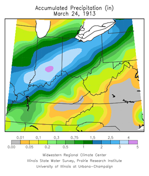
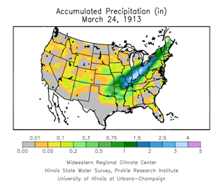
Monday, March 24th
Typically after a low moves off to the northeast, it is replaced by cool and dry high pressure. The Weather Bureau Offices for Indiana and Ohio on the morning of the 24th were calling for “unsettled weather, with rain or snow tonight or Tuesday; colder.” However in this instance, a second low-pressure system moved into the Ohio Valley. This low originated over the northern Pacific like the one on the 23rd, but this storm system had merged with a secondary low from Texas, which provided an ample source of moisture.
As if perfectly designed for maximum rainfall, a quasi-stationary front, the type generally considered to be the most efficient heavy-rain producer, was stalled over the Ohio Basin between two areas of high pressure, one off the coast of New England and another over Montana. The cooler air mass to the west acted like a cold front; meanwhile the southerly flow resulting from the east coast high provided the warm front, the two of which merged into the stationary front. The low-pressure system was the triggering mechanism to support heavy rain and thunderstorms as it moved north along this front.
 |
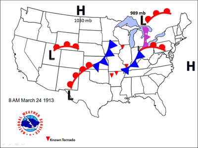 |
On the morning of the 24th the center of a second storm center was over western Colorado with another over western Texas. These systems were set to merge over a stationary front over the Ohio Valley in the next 24 hours. Meanwhile the current area of low pressure took the traditional track and lifted out of the Great Lakes and into eastern Canada and New England.
Rainfall on the 24th measured highest in southern Indiana and western Ohio averaging 3 to 6 inches. Based on National Weather Service reanalysis of the weather in 1913, it is estimated that the rainfall efficiency was significant with precipitable water values in the 99th percentile for that time of year. Storm total rainfall between Easter Sunday through Monday was a swath of 3 to 8 inches over Ohio, Indiana, and southern Illinois, surpassing monthly rainfall totals in less than 48 hours. The rain however, was far from over. The result of the rainfall to this point was significant.
On the night of the 24th and the morning of the 25th the first storm system shifted east and continued its swath of damage, this time over portions of Kentucky. Meanwhile the second storm system was moving into southern Indiana and Illinois resulting in scattered reports of tornadoes and damaging winds.
^TOP
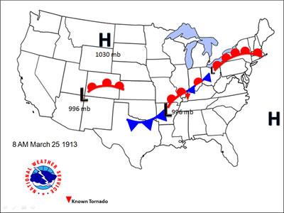
Tuesday, March 25th
 Governor Cox of Ohio was alerted to the severity of the flooding situation in the state during the early morning hours of Tuesday. In the town of La Rue along the headwaters of the Scioto River, and upstream of Columbus, an unknown source sent a wire report stating, “We must have help or we’ll be wiped out!” (Ohio almanac and handbook of information page 179.) At the same time calls for help were arriving in full force as towns covering most of the state were inundated. Unlike several past floods, this event was not in one town or on one river, but it encompassed the entire state including the capital itself.
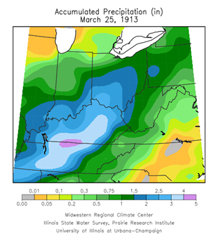
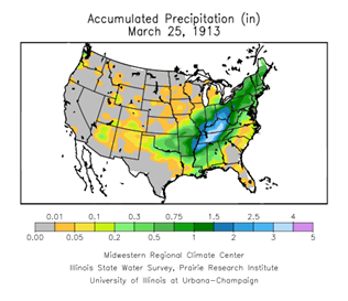
By 8:00 a.m. Tuesday the 25th, 7.00 inches of rain had fallen in Columbus, Indiana, 4.40 inches in Greenville, Ohio, 4.80 inches at Wooster, Ohio, and 3.60 inches at Tiffin, Ohio. Though the axis of heaviest rain shifted slightly southward the heavy rain continued all day over already swollen rivers. It got colder that evening turning to snow in far northwestern areas of Illinois.
An area of elongated low pressure extending from New England to Texas developed Tuesday with a center over western Pennsylvania and another over Arkansas. These positions were ideally positioned to deliver a maximum amount of rainfall over the Ohio Valley. The low over Arkansas and the low level jet were positioned to push a high volume of water from the Gulf into the region.
Over the Ohio Valley the rain continued to fall and more railroads and bridges were being damaged or destroyed across Ohio, Indiana, and Pennsylvania as powerful floodwaters swept the states. Communities were cut off from the outside world, becoming islands in many instances. Normal daily activities were suspended as flood waters kept workers and school children marooned, and those capable appeared eagerly assisting neighbors fighting the floodwaters.
 |
 |
The main levee of the Big Miami River in Dayton, Ohio broke at Webster Street around 8 am. A 10 to 20 foot wall of water swept through Main Street. All along Main Street, citizens were forced to third floors and roofs. As citizens in Dayton were reacting the to onrush of flood waters, a John Bell from the Central Union Telephone Company was intuitive enough to move to a flood free zone on a local roof. Throughout the storm he remained on the roof, connecting into phone lines and providing the only source of communication between Dayton and the outside world.
Fear quickly spread when late Tuesday morning Mayor Phillips of Dayton released a statement that an estimated 5,000 people had perished in the flood. Around this time word was also coming in about parts of Columbus were inundated with flood waters 10 to 20 feet deep after numerous levees broke. Ohio’s Governor then received reports from Hamilton, Piqua, Tiffin, Defiance, Zanesville, Youngstown, Akron, and Cleveland all with horror stories of flood waters in second stories of homes, dam failures, and loss of life. And by that afternoon, the Muskingum River was sending floodwaters towards the Ohio River. Reports from every corner of the state came pouring in. That same day, Governor Cox drew up a bill appropriating $250,000 for relief for flood sufferers in Ohio and he called out the entire Ohio National Guard into flood districts. In Indiana, conditions were just as dire. By early afternoon levees broke in Indianapolis.
“Over a score of Ohio cities and towns devastated and many of them in darkness, with the dead, dying and injured strewn in the wreckage or floating on the dirty waters, the property loss mounting into millions and the crest not yet reached, the greatest flood in its history is being written in the annals of Ohio tonight,” it stated on page one of the Cleveland Plain on March 26th. Relief trains attempted to reach the flooded areas, but damage to the tracks made it unsafe. Before midnight, the heavy rain was renewed.
Outside of the Ohio Valley the rainfall was not as significant, however many towns in western New York and Pennsylvania began to flood. Almost the entire southern half of Buffalo, New York was inundated. The worse damage at that time in New York was in Hornell, Dansville, Mount Morris, Attica, and Cumminsville. The Hudson River at Albany, the Genesee River at Rochester, the Connecticut River in Massachusetts, and the James River in Virginia all saw notable flooding and damages.
^TOP
Wednesday March 26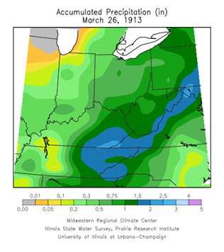
RAIN CONTINUES AS SWOLLEN RIVERS AND BURSTING DAMS INUNDATE STATES
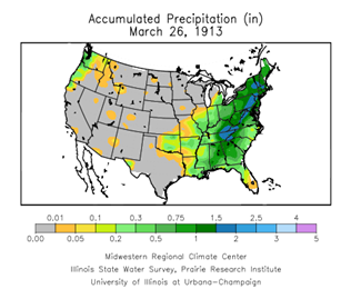
The center of the low pressure system had drifted east over New York, but the rain was slow to end over the Ohio Valley as moisture rich air continued to stream north from the Gulf of Mexico. The heaviest axis of rain had shifted to southern Indiana and Ohio and over Kentucky and Tennessee where 2 to 5 inches were measured. Over northwest Ohio and northern Indiana the rain had lightened with rainfall under a half an inch. Temperatures were in the 50s except in the north where highs struggled to reach the mid 40s.
Governor Cox issued a proclamation declaring a 10-day holiday in all districts flooded in Ohio. President Wilson and the Secretary of War ordered relief supplies to assist the state's authorities. One million rations, sufficient to feed 200,000 people for at least five days, were purchased by the War Department and hurried to the Ohio and Indiana towns. Tents and shelters for at least 50,000 persons, thousands of blankets, cots, and field supplies were being sent from Philadelphia and Pittsburgh. Unfortunately most train tracks between the east and the Ohio Valley were damaged, preventing a speedy delivery of emergency supplies. Troops were slow to make their way to the cut off and flooded communities due to so much damage to the road infrastructure and ongoing flooding.
 |
|
As conditions remained critical in Ohio, the environment over the gulf and southeastern states became favorable for tornadic storms. A series of destructive tornadoes tore through sections of Alabama and as far north as North Carolina.
^TOP 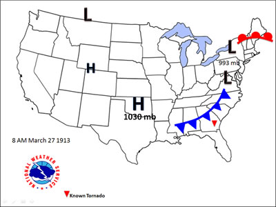
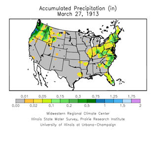
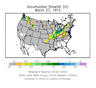
Thursday March 27
It wasn’t until midday on the 27th that a cold front followed by an area of high pressure was finally able to drive the trough of low pressure eastward into Pennsylvania and New York, slowly ending the heavy rain over the Ohio Valley. In Indiana, the rain was replaced with heavy snow, with amounts up to 8 inches over the hardest hit central and northern portions of the state. In Ohio, light snow followed the cold front that pushed through on Thursday, which was followed by cold high pressure centered over Kentucky by the 28th and resulted in widespread frosts down into the Gulf States. Heavy rain this day was falling over the northeast leading to significant flooding in Vermont, New York, Massachusetts, and Virginia.
 |
 |
 |
 |
After the Rain
By Saturday the sun finally came out, but was soon followed by a biting chill and some snow. The ban blocking travel into Dayton was lifted. The military and National Guard Battalion of Engineers from Cleveland took charge removing debris and flood damage. By Sunday the Secretary of War Garrison arrived in Dayton, with the federal government taking over sanitation needs in the city.
^TOP