The Great Flood of 1913
100 Years Later

Community Profiles: Zanesville, Ohio
| River: | Muskingum |
| Storm Total Rainfall: | 2.56" |
| Known Fatalities: | 2 or 3 |
Timeline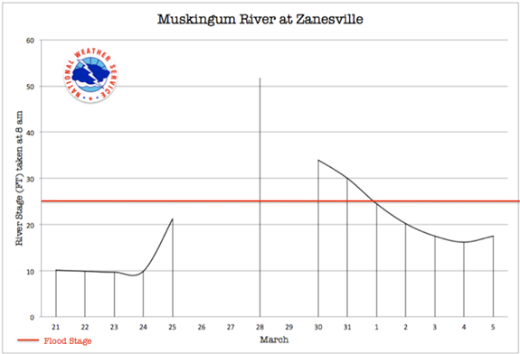
The flood at Zanesville occurred on Thursday, two days after the peak crests in Dayton and Columbus. Two rivers converge in the northern part of Zanesville, the Licking and the Muskingum Rivers, all becoming the Muskingum River which flows into the Ohio River downstream. The Muskingum River at Zanesville is about 70 miles from the mouth into the Ohio River. The river reached a stage 15 feet above the previous record as the simultaneous flood waves from the Muskingum and the Licking reached town on Wednesday and Thursday.
Impacts
The city citizens, a population of approximately 29,000 people, were caught by surprise despite the cries from upstream about the flood waters heading their way. The previous flood of record in 1893 had a stage of 36.8 feet, and the city did not believe the water would exceed that height. They were wrong. 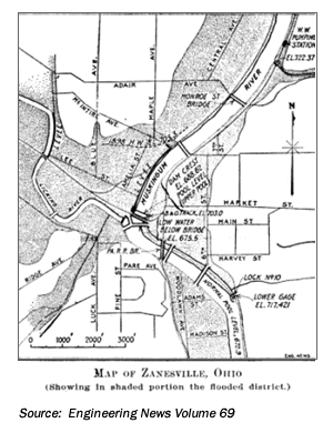 The Muskingum River reached a stage of 51.8 feet. The business district is located on the east bank of the Muskingum River, and another highly damaged portion was between the Muskingum West Bank and the Licking River. Approximately 40% of the city was flooded. The water was 20 feet deep at the corner of North and Third Streets. The current was strongest through the business district as the river took a direct route through the city instead of the normal curve just to the west. There were 3,441 buildings in Zanesville under water, 137 which were swept away. In all 8,150 were left homeless, or approximately 28% of the total population.
The Licking River, which had risen first, was eventually swallowed by the Muskingum. The Licking River was backed up substantially as a result, as far as 9 miles upstream and spread out at two points to 2.5 miles wide. Upstream of the gauge, the river stage was 15.5 feet higher than the 1893 flood, entering into the second flood of buildings in the business district.
By Wednesday morning the railway bridge was washed away, then the 3rd and 6th Street bridges. Two large railway and highway bridges were washed out, and the large concrete Y bridge was badly damaged. All bridges downstream of the Y bridge to the Marietta were too damaged or destroyed to allow travel across. 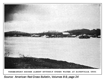 Some small dams were present upstream of Zanesville at the time of the floods, however the flood waters were as much as 29 feet above them, so no reduced flooding occurred as a result of their presence.
The pumping stations were flooded and the town was without water. The city was cut off into three sections; the only form of communication available was the use of chalkboards. There was significant damage to the canals in this region as the debris and velocity tore at the banks and locks. All bridges were wrecked by Wednesday, prior to the river cresting. The city was using raw river water for drinking, and cases of typhoid were reported afterwards. When the water receded only two known fatalities occurred, both citizens who refused to evacuate or be rescued. Deaths attributed to exposure or disease were not mentioned.
Flood Protection Measures
The Muskingum Watershed Conservancy District (MWCD), serving all of Muskingum County, was established in 1933. Flood control purposes of the MWCD were transferred to the COE shortly thereafter.
Non-structural measures in the form of land use regulations for flood protection are also being used to aid in the prevention of future flood damage along the Muskingum River. Due to the past severe flooding of the Village of Roseville, Ohio, and the magnitude of damage to the community, the Huntington District Corps of Engineers (COE) constructed a levee along Moxahala Creek to protect the community in 1960. The Village of Roseville owns the levee and is responsible for its operation and maintenance. The COE is responsible for maintenance of the
Moxahala Creek channel. There is an agreement between the community and the Huntington COE for periodic inspections of the levee to be performed by the COE.
This levee provides protection from the 1-percent-annual-chance flood event.