The Great Flood of 1913
100 Years Later

Community Profiles: Seymour, Indiana
| River: | East Fork White River |
| Storm Total Rainfall: | |
| Known Fatalities: |
Timeline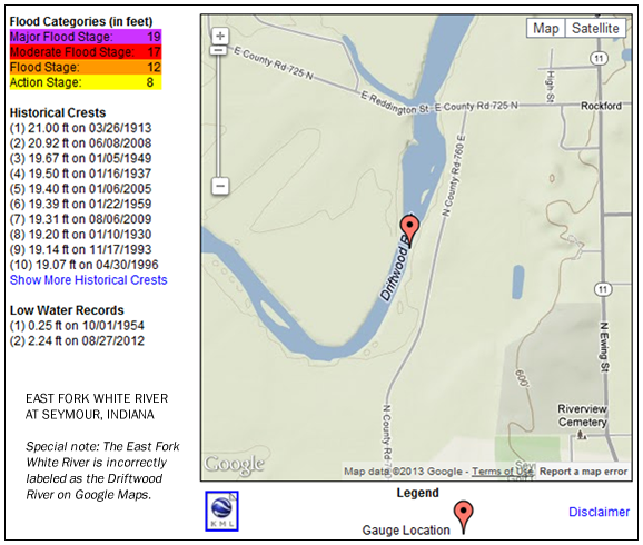
The East Fork White River at Rockford, Indiana (near Seymour) experienced a flood only an inch or so lower than the March 1913 flood on June 8, 2008. The river crested near a record stage of 20.92 feet compared to 21.00 feet in March 1913. The March 1913 flood remains the largest known volume flow for the East Fork White River near Seymour with an estimated peak flood discharge of 120,000 cubic feet per second compared to 96,400 100 cubic feet per second in June 2008.
Development in the East Fork White River’s flood plain since 1913 has reduced its flow capacity. A return of the volume of water for the March 1913 flood would cause a flood higher than in June 2008.
The Great June 2008 Flood in the Seymour and Jackson County area was the result of the tsunami-like flood wave from the Columbus, Indiana area. The Seymour area and all of Jackson County did not receive any rainfall on June 6 or June 7. Earlier rains in June had swelled the river to 17.5 feet from a normal level of about 3 feet. This was 5.5 feet above the flood stage of 12 feet. A very significant agricultural flood for June was already in progress before the sudden surge of additional flood waters arrived.
 After being stationary all day on Saturday, June 7, the river began to rise around sunset. The river rose steadily all night, some 3.5 feet above the sunset level and crested about 12 hours later around 9 a.m. EDT Sunday morning. The flood wave continued to attenuate as it moved downstream. Local reports southwest of Medora stated the flood heights were slightly lower than those of January 2005.
Impacts
The local river observer was rescued from her house during the predawn hours. Local residents awoke to a sight never seen since March 1913. Flood waters covered thousands of acres of farmland, washed out roads and railroads and flooded or affected numerous residences in the Seymour, Brownstown and Medora areas. Flood damage was in the millions of dollars in Jackson County.
Flood Protection Measures
There are no Corps of Engineers flood control reservoirs upstream of Seymour.
If you have additional information that you would like to provide about the June 2008 flood at Seymour send an e-mail to: al.shipe@noaa.gov.