The Great Flood of 1913
100 Years Later

Community Profiles: Piqua, Ohio
| River: | Miami |
| Storm Total Rainfall: | 9.38" |
| Known Fatalities: | 44 |
Timeline/Flood History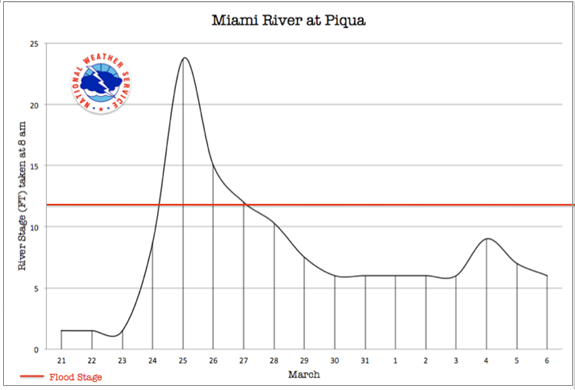
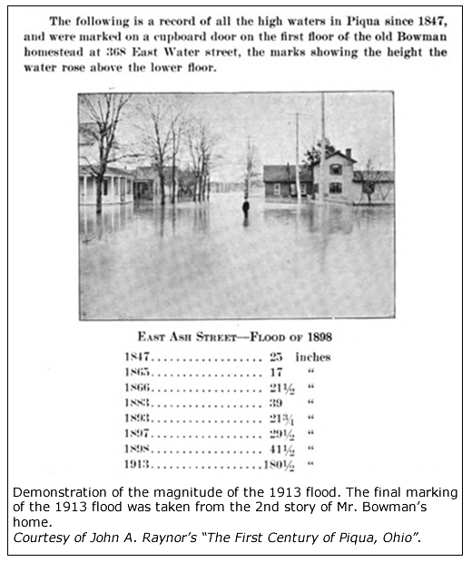
The 1913 flood event is considered to be the most severe for the region. In his 1916 publication, “The first century of Piqua, Ohio”, author John A. Raynor provides accounts of Piqua flooding in 1805, 1835, 1847, 1866 and 1898, with the most severe being those of 1847, 1866 and 1898, with each having washed out several bridges and flooded homes. As with many northern Ohio communities, none of these floods were close to the magnitude and devastation which was the 1913 flood. Additional details of the historic floods of Piqua, including 1913, can be found at the Piqua Public Library 1913 flood page.
During this event, the Great Miami River had a discharge of 70,000 cubic feet per second (cfs), though the channel capacity was only for 25,000 cubic feet per second. This correlates to approximately a 0.2% flood event or greater (or a 1-in-500 chance of this flood in any given year, previously referred to as a “500 year” flood).
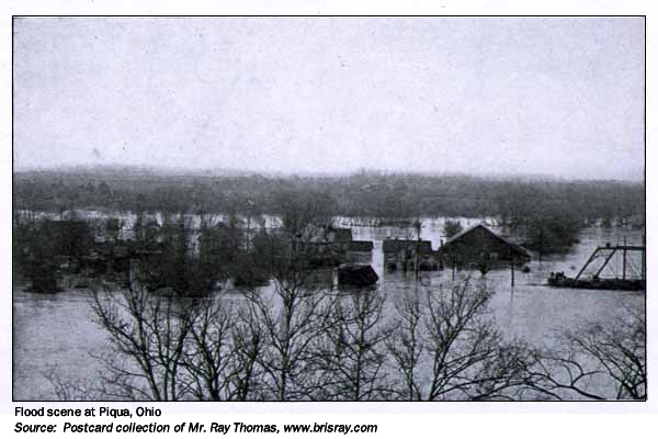
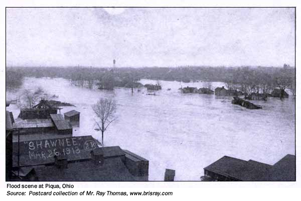
 Most of the population of Piqua was located on the west side of the river. The river rose on Monday passing the previous flood of record of 1898 by that evening. Overnight, levees that protected the town were overtopped and the Ohio-Erie canal was flooded. The river crested late Tuesday morning, March 25, completely submerging the Piqua district of Shawnee located on the east bank of the river. It was in this location that most of the 44 deaths had occurred. The river at Piqua is characterized by a large bend in the river. Such a channel characteristic can cause water to completely inundate areas within the bend, often with very rapid river flow. It is possible this was a substantial contribution to the rapid flooding and loss of life at Piqua. The flood waters receded by late Thursday.
Impacts
In all, fifty percent of the town was flooded, resulting in 44 lives lost. The worst flooding occurred in the southern part of town and west of Main Street. Rossville and Shawnee, which were within the loop/bend in the river, were the most devastated as the river consumed this entire region with water 15 feet deep. In the business district, the water on Main Street was 6 feet deep. Approximately 2,000 of the town's nearly 13,500 residences were flooded; 100 or more homes were destroyed. Early rumors that the Loramie Reservoir located just upstream of Piqua was about to fail caused panic, though the rumor was false and the reservoir held, despite offering little protection to the downstream flooding. These rumors did possibly contribute to the ultimate loss of life at Piqua. When warnings of massive flooding and the possibility of failed levees did come, some citizens were not quick to heed these warnings which were, sadly, eventually validated.
Flood Protection Measures
The approach taken by MCD was revolutionary in that 5 dry dams operated on the Great Miami and its major tributaries. Piqua benefits from the creation of Lockington Dam on Loramie creek, as well as the levees and flood gates. The design concept of Lockington is such that it is able to retain water without gates or an operator. Land upstream of Lockington serves as park land, so structures are largely not affected by pooling of water behind each dam during high river flow.
Prior to MCD involvement, Piqua itself had raised existing levees that had either failed or were overtopped by the 1913 flood. With the large bend in the river being protected by this levee, lead engineer of the fledgling MCD, Arthur Morgan, wrote that it would be impracticable to straighten this area or to provide a cutoff channel. Instead, Morgan worked with the community to further substantiate their existing levee and to widen other parts of the river channel through Piqua. The channel capacity today is much greater than that of 1913. The combined approach is designed to protect the population centers in the Miami basin to a flood surpassing the volume of water from the 1913 flood by an additional 40%. This level of protection surpasses that of a “1 in 500 chance” flood in any given year (a 0.2% flood), which has been historically known as a ‘500-year’ flood.