The Great Flood of 1913
100 Years Later

Community Profiles: Mount Carmel, Illinois
| River: | Wabash |
| Storm Total Rainfall: | |
| Known Fatalities: |
Timeline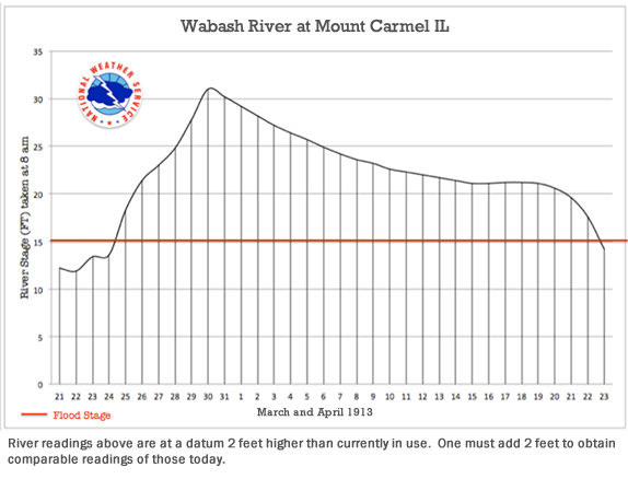
Prior to the widespread prolonged rain event of March 23-27, 1913, the Wabash River at Mt. Carmel was at an elevated level because of rains earlier in March. Typically, the Wabash River at Mt. Carmel is a reflection of the overall rainfall for the past 7 to 10 days in the entire Wabash River Basin. The Wabash River at Mt. Carmel drains about 70% of the state of Indiana and has a drainage area of 28,635 square miles, or about 80% the size of Indiana.
From March 23 through March 27, rainfall of nearly 5 to more than 10 inches fell on mostly saturated soils in the Wabash River Valley. Heavy rainfall occurred first in the northern part of the watershed and then moved southward later in the period. Overall the heavier rain fell in the southern and steeper terrain of the Wabash Valley. The flood crest moved quickly through the valley, exiting into the Ohio River by April 2, 1913. (See the rainfall map, below.)
The March 1913 flood is the largest known volume flow for the Wabash River at Mt. Carmel. Because local levees constrict the Wabash River at Mt. Carmel, the March 1913 flood is no longer the highest by river gauge readings. The current gauge record of 34.02 feet was set on May 3, 2011 during the April-May 2011 flood, compared to a 33 foot crest (today’s datum) in March 1913.
The Wabash River broke all levees in the local area during March 1913 and was 8 miles wide. This was not the case in May 2011. Comparing the estimated peak flood discharge of March 1913 (428,000 cubic feet per second) to the May 2011 (270,000 cubic feet per second), the May 2011 flood had only an estimated 63% of the flow of the March 1913 flood.
Comparing the March 1913 flood to the August 1875 flood (320,000 estimated peak flow and the second highest known volume flow of record), the estimated peak flow of the 1875 flood was only an estimated 75% of the peak flow of the March 1913 flood.
Impacts
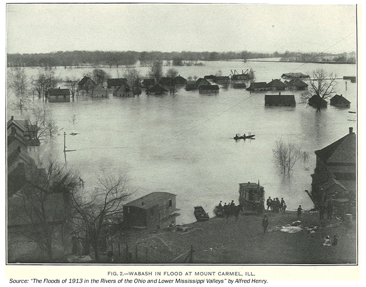
The March 1913 flood was unprecedented for the lower Wabash Valley. Flood waters covered much of northern and western Gibson County, Indiana as well as lower portions of Wabash County, Illinois and inundated thousands of acres of farmland. Although a very rural area, as shown in the picture later, a number of residences flooded, railroad transportation halted and rescues were needed. Princeton Clarion News reported at least 34 people marooned in the upper stories of two houses in East Mt. Carmel, Indiana. All power and water service was out in Mt. Carmel, Illinois. For a time all communication between Indianapolis and Princeton was down. More than 35 other families were being sheltered.
Headlines in Princeton, Indiana (approximately 12 miles east of Mt. Carmel) newspaper of March 1913:
- March 28: "C & E I Dump at Hazleton doomed, levee leading to it is partly gone"
- March 28: "Rivers are all rising steadily, unpatrolled damage probable"
- March 29: "Northern and Western Gibson a sea of water rising an inch and a half an hour"
- March 31: "Water falling, but wind lashes waves and greatly endangers rescue work"
Flood Protection Measures
In the vicinity of Mt. Carmel, flood protection measures are provided by the Mount Carmel Local Flood Protection Project and include a system of levees, floodwalls, and pumping stations. This project was initiated in December 1966 and was completed in October 1968.
The severity of Wabash River flooding has been reduced slightly by the construction of seven upstream Corps of Engineers flood control reservoirs including the JE Roush, Salamonie, and Mississinewa reservoirs on the upper Wabash River, and Cecil M. Harden on the middle Wabash River. Contributing flows from the White, East Fork White and Patoka Rivers are reduced slightly by Cagles Mill, Monroe and Patoka reservoirs. All seven Corps reservoirs combined provides flood control benefits for 11% of the total drainage area upstream of Mt. Carmel.
Levees exist in the study area that provide the area with some degree of protection against flooding, but that do not protect against the 1-percent-annual chance flood (formerly 100-year flood), are not considered in the hydraulic analysis of the 1-percent-annual chance floodplain.