The Great Flood of 1913
100 Years Later

Community Profiles: Middletown, Ohio
| River: | Great Miami |
| Storm Total Rainfall: | ~9 (no official observation) |
| Known Fatalities: | None within city; possibly 6 in surrounding area. |
Timeline/Past Floods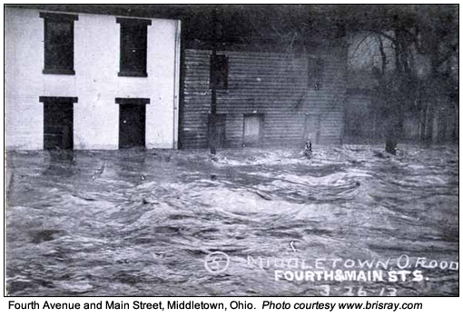
Past Floods
From the time of its original settlement in 1791, Middletown had experienced several floods along the Great Miami. Among the earliest recorded flood in Middletown’s settlement were as early as 1805. This was followed by flooding in 1814, 1828, 1847, 1866, and 1898. In 1898, flood water from the river flowed up old Fifth Street (Second Avenue) to the Main Street intersection, flooding many downtown basements.
Timeline
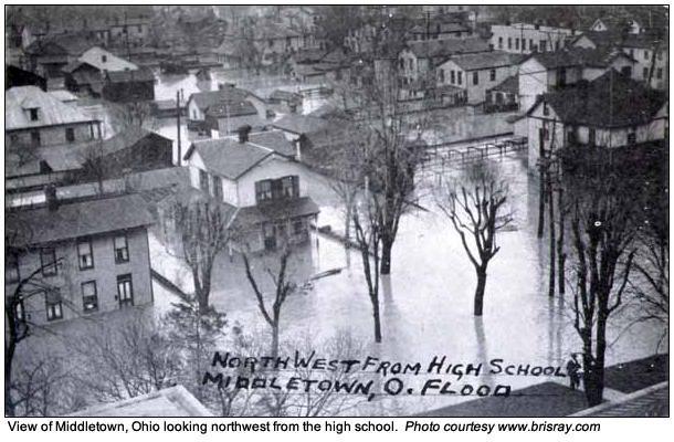
At the time of the 1913 flood, Middletown in northeast Butler county had a population of roughly 15,000. Over 25 percent of the city was flooded, including the business district and a large section of residential regions. While there were no deaths within the city of Middletown itself, 6 people lost their lives just outside the city.
The 1913 flood discharge in Middletown was roughly 304,000 cubic feet per second in terms of the total volume of water which passed through the Great Miami through the city. The calculated channel capacity for the Great Miami at that time, as determined by Arthur Morgan of the Miami Conservancy District, was 115,000 CFS for the town, with no levees and a wide flood channel.
Impacts
As with several other cities inundated by this unprecedented flood, there were also a series of fires and explosions which compounded Middletown’s flood losses throughout the residential district.
The Cincinnati Police Department rescued many of the citizens of Middletown during the 1913 Flood. They were able to get into Middletown on the Pennsylvania Railroad, which was the only rail line in operation to the city. The police brought boats and other equipment to assist them in their rescue efforts.
Flood Protection Measures
The City of Middletown is protected from 1-percent-annual-chance Great Miami River flooding by a system of levees constructed and managed by the Miami Conservation District (MCD). The north section of the levee begins at State Route 73, and extends north and west to Terry Drive. At this point, the levee extends downstream along the east bank of the Great Miami River to Central Avenue. The levee begins again at a point north of 2nd Avenue and extends downstream to a point south of 11th Street. The south section of the levee begins downstream of 15th Avenue and extends downstream to a point south of State Route 73. At this point, the levee turns to the east along the north bank of Dicks Creek to its termination at State Route 4.
Levees exist along Dicks Creek and Shaker Creek that provide the community with some degree of protection against flooding. However, it has been ascertained that these levees may not protect the community from rare events such as the 1-percent-annual-chance event flood, and are therefore not considered in the hydraulic analysis and floodplain delineation.