The Great Flood of 1913
100 Years Later
Community Profiles: McConnelsville & Malta, Ohio
| River: | Muskingum |
| Storm Total Rainfall: | 5.57" |
| Known Fatalities: |
Timeline
The Muskingum River flood of record in Morgan County occurred in March 1913, prior to the construction of the flood control dams in the Muskingum River Basin. McConnelsville is located downstream of Zanesville, a city particularly devastated by flooding. Of the 31 houses and farms between Zanesville and McConnelsville, only 13 were left standing. McConnelsville and neighboring Malta had a population of 2,000 and 1,000 respectively at the time of the floods. In Malta 200 families were homeless and in McConnelsville 250 families were homeless. Assuming an average family size of 5 at the time, that is approximately 75% of the total population of the two towns homeless.
The water was as much as 30 feet deep in McConnelsville, and 28 buildings were washed away. Fortunately the majority of the town was located on the hills. Malta however lies mainly in the floodplain, and 60% of the town was flooded. Below are notes from a cooperative weather observer in Malta at the time, a Mr. C.H. Morris.
Impacts
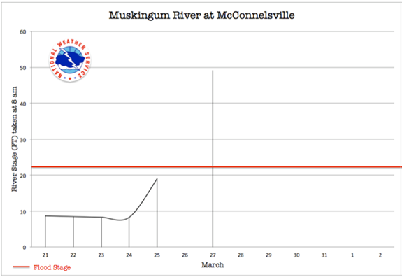
“It began raining on Sunday and the rainfall was pretty continuous until Thursday morning when it totaled 4.43 inches. On Tuesday afternoon at 5 p.m. a message came fron Zanesville stating that they expected there 10 feet more water than had ever before been recorded. We, figuring from our past experience that the broad bottoms of the Muskingum Valley which had taken care of so much of the flood water heretofore and would do it again, counted on probably 5 feet more water here than in 1898. Well, we got it, and to spare. All day Tuesday the river rose steadily, but not alarmingly until at dark it bagan rising in earnest reaching the gage mark of 19 feet at 11 p.m. Then the people along the river front who had decided to await that morning for developments got busy, and drays, wagons, and all available persons were requisitioned for aid.
On Wednesday morning by 7 a.m. the gage showed 25 feet being within a foot and a half of the 1898 rise, passing the former record of 26.4 feet by 10 a.m. From now until the middle of the afternoon the rate of rise was 13 inches to the hour, and at 9 p.m. the stage of water showed 36.4 feet, which was exactly 10 feet in 11 hours. At half past noon the big middle span of thebridge, struck by a heavily timbered building, turned gracefully over and sank quietly in the yellow torrent. An hour later the Malta span similarly met its fate.
During the afternoon an unending procession of mills, bridges, railroads cars, barns, dwellings, everything that is indispensable to civilization, went pell-mell down the still rising waters, and darkness came again-but no sleep. Hundreds of people began making their second move. As the flood swiftly encroached upon streets heretofore far removed from the hungry river, and with all gage marks gone. Thursday morning, the 27th, dawned cold and cheerless with snow in the air.
The river now had reached a height of 39 feet, and was rising a bare 2 inches per hour, and at 9 p.m. touched its highest point, 40.8 feet where it stood until early Friday morning. All day on Thursday the turgid Muskingum was the mecca of the inhabitants of the Twin Cities, now as far removed from each other as though in separate states, seeing each other from the hillsides, yet having no communication and hearing nothing from the outside world either.
Malta was much more sorely hurt than McConnelsville. Not a single business there but was put out of commission. The Mantel canning factories each were carried away, the latter dropping a line of canned goods for a good mile. Parts of the main buildings of both the Hoffman tannery and the B.M plow company drifted off. The Rogers Building-one of the landmarks of the valley-having borne the onslaught of the ice and water for almost three-quarters of a century, and having four prosperous places of business within its walls, floated off with all its contents. The Elk Eye flouring mill-the largest building in the valley and one of the oldest-lost its north wing on Thursday forenoon and went sailing away, crushing giant trees and leveling a brick house in its wake ere it got out into the river; $10,000 would not cover this one loss.
The river hills at the upper end of McConnelsville closely approach the river at a point almost midway of Malta opposite where the hill likewise juts well over the bottom land, so that when 30 feet of water is reached in the valley the current between the two towns is of tremendous swiftness. It is a curious fact that the Muskingum River floods in the past have averaged, with one exception, 14-year intervals, each exceeding the other by about 2 feet.” Source: The Flood of 1913 in the Rivers of the Ohio and Lower Mississippi Valleys by Alfred Henry.
Flood Protection Measures
Flood protection for Morgan County along the Muskingum River is provided by a system of 16-flood control reservoirs built on upstream tributaries. Fourteen of these reservoirs were constructed between 1934 and 1938, with two additional reservoirs, Dillon Lake and North Branch Kokosing Lake, completed in 1961 and 1972, respectively. These reservoirs control approximately 68 percent of the total drainage area of the Muskingum River above McConnelsville. These reservoirs provide same protection against the 100-year* flood.
* 100-year flood is old terminology. Agencies are now using the term "1% Flood Level" which is the maximum flood level with a one-percent chance of occurring within any given year.

