The Great Flood of 1913
100 Years Later

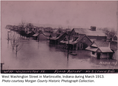
Community Profiles: Martinsville, Indiana
| River: | White |
| Storm Total Rainfall: | |
| Known Fatalities: |
Timeline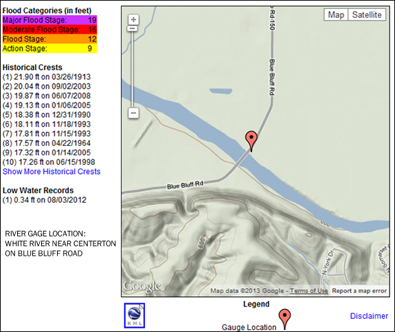
There are two river sites for use by Martinsville residents. The first is the White River near Centerton located on Blue Bluff Road. This site has continuous river readings available and is a daily river forecast site.
The second site is located about a mile and a half downstream at the Eagle Valley Power Plant. River readings for this location are unavailable for much of the time. River forecasts are issued only when the White River is expected to approach or exceed flood state.
The following is an article written by Janice Kistler, Reference Librarian at the Morgan County Public Library.
Diary of the 1913 Flood excerpted from “The Daily Reporter” Martinsville newspaper, author unknown.
Tuesday, March 25, 1913
The rain poured all day Monday and almost incessantly during the night and while people believed that there would be trouble from rising waters, no one was expecting such a state of affairs as exists here today.
Wednesday, March 26, 1913
When dawn came this morning flood conditions were worse than at any time Tuesday and the water was still rising. It was reported that White River rose seven inches during the night.
 Thursday, March 27, 1913
The water did not fall very rapidly last night, but this morning it was reported that the river had gone down about ten inches.” To make matters more difficult a cold snowstorm blew in that morning. The river had fallen between eight and ten inches this morning about nine o’clock, and the opinion was expressed that it would recede quite rapidly in the next twenty-four hours.
Friday, March 28, 1913
Flood conditions continue to improve in this city and this morning it was estimated the water in White river had gone down a foot from what it registered yesterday morning. This showed that the water was receding and that it will be some time before the river is back in its regular channel.
The bright sunshine this morning helped to give the people a more cheerful view of the situation, and much gratification was expressed over the fact that in all the turmoil and confusion…no lives have been lost here.
Impacts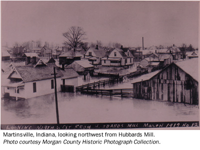
Two local residents, Mr. Ed Shireman and Mr. E.C. Shireman went to check on the farm belonging to Mr. Crone. On their way to the farm they went to the bridge and found a spike that another resident, James A. Lewis had placed when the flood of 1875 had reached its highest crest. They discovered that “the water had lacked three and one-half inches of reaching the spike, denoting that the flood of 1875 was higher than that of this year.” However, at the time of the flood of ’75 there were thousands of trees between the river and this city that held back the water in a measure. Now the fields are clear and the waters have a greater sweep. There has never been a larger volume of water passed down the river bed than has flowed down this week. At Whitaker (just south of Martinsville) it is reported to have been five inches higher than in ’75. Headlines of the Thursday, March 27th paper announced that the water was “TWO FEET HIGHER AT BROOKLYN THAN IN ‘75”.
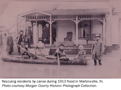
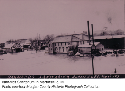
Over 300 families were displaced by the flood. Many of them did not believe the rains would be a problem until the water started entering their homes. Most had to be rescued by vehicle or boat. The entire west side of the city experienced extensive flooding. Steam and Electric Railway tracks were damaged by the flood which stranded a few people who expected to return home to Martinsville by rail. Sanitarium guests were also displaced by the flood.
Flood Protection Measures
There are no Corps of Engineers flood control reservoirs upstream of Martinsville. Eagle Creek Reservoir is operated for the benefit of Indianapolis and has little benefit for the Martinsville area. Flood levees exist in the Martinsville area and provided protection for lesser floods than March 1913.
To add information about the March 1913 in the Martinsville area e-mail Al Shipe at al.shipe@noaa.gov.