The Great Flood of 1913
100 Years Later

Community Profiles: Lafayette, Indiana
| River: | Wabash |
| Storm Total Rainfall: | 4.59" at Purdue farm 6 mi. NW of West Lafayette |
| Known Fatalities: | 3 |
Timeline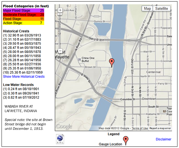
From “Flood on the Wabash River in March 1913” by W.R. Cade, US Weather Bureau Observer.
Early Sunday March 23 readings were near normal for late March at Lafayette. A heavy rain fell on March 23 over the entire district and by Monday morning amounts ranged from 1 inch at Terre Haute to nearly 4 inches at Bluffton. This heavy rain caused the river to rise at a record-breaking rate. The river was above flood stage of 11 feet at Lafayette by Monday morning, the 24th. The heavy rain continued Monday and the amounts on Tuesday morning were equally as large as those the previous morning and ranged from 2 to 3 inches. The river continued to rise very rapidly.
A break in the rainfall occurred during the day on Tuesday because only slight amounts of rain were reported on Wednesday, March 26. The rain changed to snow on the 26th with 6 inches accumulating in the Lafayette area.
Impacts
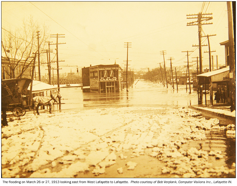
March 1913 brought the worst flood in Tippecanoe County’s recorded history. By the end of the day on March 26th, the iron Main Street Bridge fell, part of the Brown Street Bridge gave way, railroad and mail service stopped, streets flooded, and buildings washed away or collapsed, leaving West Lafayette isolated from Lafayette. The water, gas, heating and electric plants at Lafayette discontinued operations and Lafayette was left in the dark and cold.1
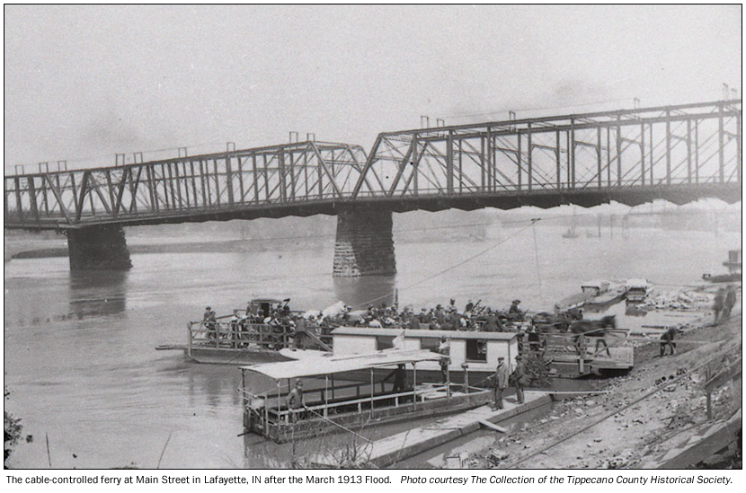
At 10 p.m. on the 26th the river crested at just less than 33 feet; 28 to 30 feet higher than on March 22nd. Once the water receded a cable-controlled ferry operated across the Wabash River at Main Street. At the end of April the Brown Street Bridge reopened, however Main Street Bridge did not open until November 1914.1

Flood Protection Measures
Three Corps of Engineers reservoirs (JE Roush, Salamonie and Mississinewa) provide combined flood control benefits for about 29% of the drainage area upstream of Lafayette and moderately reduce Wabash River flooding in Lafayette. Major river flooding is still possible in the Lafayette area.
To update information about the March 1913 flood story of Lafayette contact Al Shipe by e-mail al.shipe@noaa.gov.
1) Kathy Atwell, Executive Director of the Tippecanoe County Historical Association.