The Great Flood of 1913
100 Years Later

Community Profiles: Indianapolis, Indiana
| River: | White |
| Storm Total Rainfall: | 7.76" |
| Known Fatalities: | 5 |
Timeline
The White River which flows through Indianapolis is a tributary to the Wabash River. The White River borders West Indianapolis from the east, and the Eagle Creek to the west.
On Tuesday the Weather Bureau sent out the following warning: “Below Indianapolis the river will rise rapidly and the public should prepare for higher stages than have been experienced for many years. Every precaution should be taken by those living along the lower course of he river, as the rise will be unusually rapid and will reach a point several feet above the danger line.”
The levee began failing late in the morning on Tuesday, March 25th, flooding West Indianapolis from the White River, and soon after the Eagle Creek. Flood waters reached 15 feet deep in the valley of West Indianapolis. Fortunately, most citizens had heeded the warnings and had evacuated to higher ground, reducing the loss of life. The Washington Street Bridge was destroyed on Wednesday, separating the main connection between West Indianapolis and Indianapolis. The gauge washed away the night of the 25th-26th. The crest of the flood passed Indianapolis the morning of the 26th.
Impacts
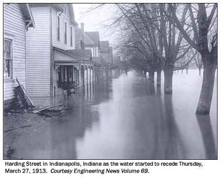
The recently-made suburb of West Indianapolis and valley of West New York Street were the hardest hit area; a region known for workers in the railroads and stockyards. The damage unveiled when the water receded was substantial and the worst flood the region ever saw. In all, a six-square mile area was inundated and 4,000 families saw their homes damaged or destroyed. The loss of life stands at five known, however stories from witnesses suggest the total may be higher.
Flood Protection Measures
There are no Corps of Engineers reservoirs upstream of Indianapolis.