The Great Flood of 1913
100 Years Later

Community Profiles: Hamilton, Ohio
| River: | Great Miami |
| Storm Total Rainfall: | ~9" (no official observation) |
| Known Fatalities: | Approx. 100 |
Timeline
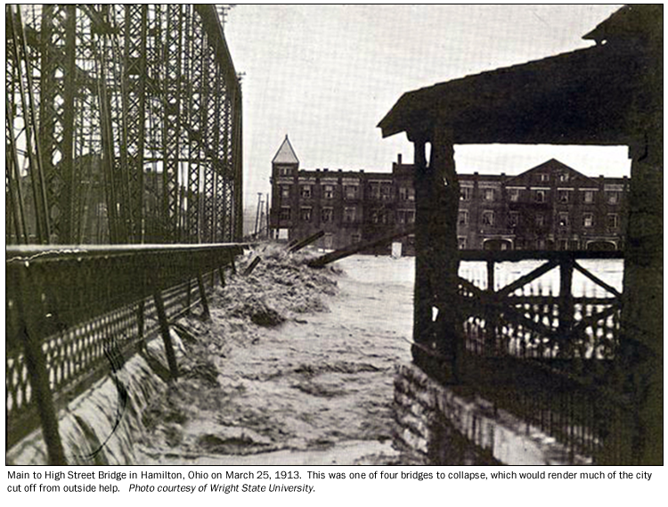
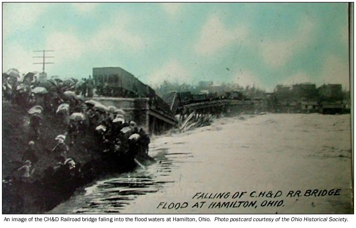
Hamilton residents had experienced floods along the Great Miami in previous years, with floods in 1898 and 1907 being the highest in recent memory on the existing river gage at the time, at 21.2’ and 20.3’, respectively. These previous records paled in comparison to the magnitude and devastation which was the 1913 flood. A very rapid rise especially during March 25th brought the worst of the devastation, with the river cresting at 34.6’ near 1 a.m. on March 26th, over 13 feet higher than residents of Hamilton had ever experienced with previous floods.
With Hamilton receiving the drainage of the upper and middle Great Miami basin, 3500 mi2 of the river’s drainage passed through Hamilton. The river rose roughly 30 feet in 48 hours, with the greatest rises and devastation occurring on March 25. During the afternoon of March 25, two public use bridges and one railroad bridge had collapsed, with the remaining bridge over the cresting Great Miami (the Columbia Bridge) collapsing at about 2 a.m. on March 26th. During the afternoon of March 25th, Gordon Rentschler of Hooven-Owens-Rentschler engine manufacturer made a call for aid to the Cincinnati Safety Director Dennis Cash. The initial relief party sent by Director Cash arrived by nightfall to a river rising at a reported 3 feet per hour.
During the flood at Hamilton, the Great Miami River had a discharge of approximately 350,000 cubic feet per second (cfs), though the channel capacity was only for 100,000 cubic feet per second.
Impacts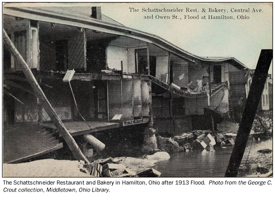
Over 75 percent of the city was inundated, with thousands of citizens, city officials and the Mayor of Hamilton marooned in the central portion of the city. With no safe rescue in this location possible, the Cincinnati rescue crew focused their efforts first in the surrounding areas. By the afternoon of March 26th, relief was underway for the thousands of stranded people in south Hamilton, with many being rescued from trees and rooftops.
With the Great Miami River bisecting the city of Hamilton, the cumulative effects of 9” to 11” rainfall over the river basin resulted in over 100 deaths. It has been estimated that indirect deaths due to diseases such as cholera and typhoid resulted in dozens more deaths in the weeks and months following the flood. The flood caused the complete destruction of over 300 buildings, with another 2000 buildings having to be demolished as a total loss. More than 10,000 people were left homeless, which was over 25% of the total city’s population.
Flood Protection Measures
Arthur Morgan, early design engineer for the original planning for the Miami Conservancy District wrote in 1951 that,
“The situation at Hamilton presented the most difficult problem of any of the cities in the valley. Above this point the river has a drainage area of 3500 square miles, about 50 percent greater than the drainage area above Dayton. Notwithstanding this fact, the channel at Hamilton at its narrowest point was only 390 feet in width. However, the channel at Hamilton was several feet deeper than that at Dayton. A large section of Hamilton is situated on each side of the river, and along both banks buildings stood close to the edge of the channel. In some instances those buildings were industrial works of considerable size and importance. The removal of many of these buildings was involved in the improvement…The entire improvement calls for the excavation of about 2,000,000 cubic yards of material.”
Upon the excavation, the great channel depth and the steep surface slope results in such high velocities at high flow, such that concrete protection was provided along a portion of the channel.
Hamilton was the furthest downstream area along the Great Miami to benefit from the flood control efforts of the Miami Conservancy District. The approach taken by MCD was revolutionary in that 5 dry dams operated on the Great Miami and its major tributaries (Lockington on Loramie Creek, Taylorsville along the Great Miami, Huffman along the Mad River, Englewood along the Stillwater River, and Germantown along Twin Creek). These structures are able to retain water without gates or an operator. Land upstream of each dam serves as park land, so structures are largely not affected by pooling of water behind each dam during high river flow. MCD also worked (as mentioned above) to widen and straighten the river channel in areas which were particularly flood prone. In addition to the 5 dry dams and increased channel capacity, Hamilton is also served by levees and flood gates. The combined approach is designed to protect the population centers in the Miami basin to a flood surpassing the volume of water from the 1913 flood by an additional 40%. This level of protection surpasses that of a “1 in 500 chance” flood in any given year (a 0.2% flood), which has been historically known as a ‘500-year’ flood.