The Great Flood of 1913
100 Years Later
Community Profiles: Elliston, Indiana
| River: | White |
| Storm Total Rainfall: | 8.00" |
| Known Fatalities: |
Timeline
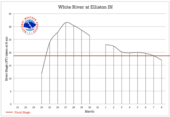
The White River at Elliston crested at 31.7 feet on March 27, 1913.
In comparison, the White River crested at 32.95 feet on June 9, 2008, about one foot higher than in March 1913. The Great June 2008 flood was the result of 8 to possibly more than 12 inches of rainfall falling in a 12-hour period on saturated soils in much of Clay and Owen Counties late on June 6 and early on June 7. Prior to the rain, the White River in Greene County and Eel River in Clay County were already out of their banks and rising slowly.
Impacts
Flood waters covered thousands of acres of farmland, overtopped levees, washed out roads and railroads, and flooded or affected more than 50 residences. Governor Daniels referred to Worthington, located about 6 miles due north of Elliston, as “The Isle of Worthington” because the town was surrounded by the Eel and White Rivers. At the height of the flood, travel in much of Greene County was virtually impossible.
The June 2008 flood was higher than March 1913 for all of the White River in Greene County and the northeast portion of Knox County and northeast portion of Daviess County. By the time the flood wave reached U.S. Highway 50 near Washington, Indiana the June 2008 flood was similar or lower than the March 1913 flood. Below are aerial photos of the June 2008 flood.


Flood Protection Measures
Cagles Mill Lake, a Corps of Engineers flood control reservoir upstream of Elliston, provides some flood control benefits at Elliston. Local levees provide flood protection. Note: the heaviest rain during the June 2008 flood fell in areas that were not controlled by Cagles Mill Lake.
If you have additional information about the March 1913 flood at Elliston, send an e-mail to: al.shipe@noaa.gov.

