The Great Flood of 1913
100 Years Later

Community Profiles: Columbus, Ohio
| River: | Scioto |
| Storm Total Rainfall: | 6.97" |
| Known Fatalities: | 92 |
Timeline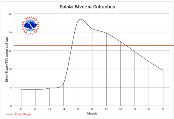
Columbus had a unique view of the floods in March of 1913 as a victim and as the Capital of a state experiencing its worst ever natural disaster. The Governor of Ohio at the time was a man named John Cox. Governor Cox had been awakened early on Tuesday the 25th of March after scores of pleas for help were wired in from communities in the north and west. From a Mr. Kniffin, manager of a local business in La Rue, “We must have help or we’ll be wiped out!” was the appeal to the Governor. At this time the Scioto, Miami, Maumee, and many Lake Erie river basins were experiencing historic flooding. Meanwhile, in Columbus the full force of the flood was just arriving. Before the day was out the word of the floods in Ohio and Indiana would steal headlines across the country.
The confluence of the Olentangy River and the Scioto River occurs in northern Columbus, and it was at this confluence that a destructive flood and loss of life without precedent in the history of the city unfolded. At the confluence lied a large concrete dam constructed for water storage purposes. The Scioto River had a levee system on the western bank from the Dry Run confluence running about 7 miles through the city. The levee system was made 6 feet above the previous flood of record in 1898. Most of the levee system had railway tracks along it.
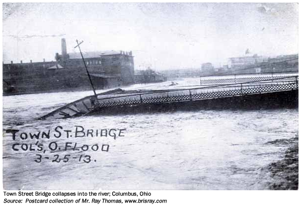
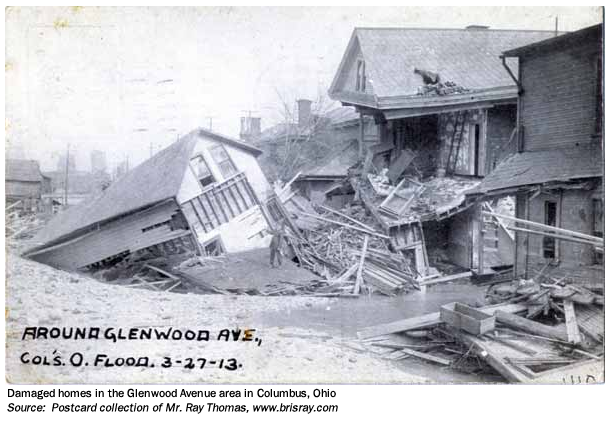
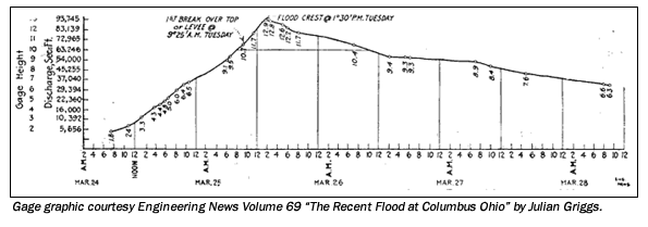 On Monday morning the Scioto River had a stage of 6.2 feet. It rose steadily through the day and it passed flood stage by that evening. On Tuesday morning at daybreak the 1898 record stage had been surpassed. Water 10 feet high was flowing over the storage dam at the confluence of the two rivers. Soon the levee systems were overtopped. At 9:25 a.m. the levee on the west side district was overtopped. The embankment soon crumbled opening 6 new holes in the levees. Approximately 2.75 miles of the 7 mile levee was destroyed. The west side of town was filled with 15-20 feet of water. Two streets, Glenwood and Central Ave were completely destroyed, one home being found 4 miles south of Columbus when the flood waters receded. The total flooded district was ¼ miles wide and a mile in length. The worst damage occurred Tuesday night. On Wednesday a false rumor of a large dam upstream had broken caused panic. Fires broke out Tuesday and Wednesday, but the fires were localized with considerably less damage than the flood waters.
Impacts
Based on estimates from observed rainfall, the Weather Bureau calculated a total water volume in the Scioto River basin above Columbus amounted to 235,813,912,500 gallons! The river gauge located at the Mound Street bridge showed a crest only 1.6 feet above the 1898 flood. This is somewhat misleading considering the amount of volume taken out of the river and into the west side which lingered into Friday the 28th.
Columbus building department damage estimates personal property damage totaling $1.5 million, nearly 500 building destroyed and 4,071 damaged. The number of reported lives lost was 92. The population estimates at the time of the flood were around 30,000, and during the flood 20,000 were homeless consisting of 4,474 families.
Flood Protection Measures
The Scioto River has no mainstream regulation. Following the March 1913 flood, the City of Columbus began to invest in Scioto River channel improvement. This included widening the channel, constructing levees and revetments and increasing bridge spans. A levee was constructed along the west bank of a reach of the Scioto River. A portion of this project is a 1,200-foot long concrete wall constructed to an elevation 3 feet lower than the top of the levee. This section is designed to act as a spillway during extreme floods to prevent the downstream levees from being overtopped and damaged. It is located approximately one-half mile below 'the mouth of the Olentangy River, extending upstream from Broad Street to the CONRAIL Bridge. After the 1959 flood, Dry Run levee was raised and strengthened and a levee segment along Dublin Road was constructed. However, this levee is not recognized as providing protection from the base flood.
Prior to 1951, flows on the Olentangy River were unregulated, but since that time the U.S. Army Corps of Engineers (USACE) Delaware Dam and Lake Project has had a major effect on reducing flood peaks on the Olentangy River through Columbus and Franklin County.
The dam is located in Delaware County, 164.4 miles above the mouth of the Scioto River, and 32 miles above the mouth of the Olentangy' River. Its total storage capacity of 132,000 acre-feet is equal to 6.5 inches of runoff from a 381 square mile drainage area above the dam. Construction was initiated in 1946 and completed in 1951. Alum Creek Lake, a multi-purpose reservoir on Alum Creek in Delaware County upstream of the City of Westerville and west of Africa, Ohio, was authorized by the Flood Control Act of 1962. The dam was completed in 1964 and is in operation for flood control and provides for additional water supplies for the Columbus metropolitan area, wildlife conservation and general recreation.
Located 26 miles above the mouth of Alum Creek and 4.5 miles upstream of Westerville, the dam controls runoff from a drainage area of 123 square miles, providing storage of 7.2 inches of runoff and sufficient water supply storage to assure 40 million gallons per day withdrawal.
Other existing water resource projects include a small water supply intake dam at Westerville, a low water dam below the CSX Transportation railroad bridge, and a low water dam between Main and Broad Streets. These projects have a minimal effect upon flooding conditions.
Hoover Dam, a water supply project, was built by the City of Columbus in 1954.This project is located on Big Walnut Creek approximately 37 miles above the mouth. Because this is a water supply dam, it is not recognized as providing flood protection.
The USACE was authorized by the Flood Control Act of 1938 to construct the Big Darby Lake Project as a part of the general comprehensive plan for flood control in the Ohio River basin.
The USACE, Huntington District constructed a floodwall along the Scioto River as part of the West Columbus Local Protection Project, also known as the Franklinton Floodwall. This Federal project is a 7.25-mile long local protection project along the western bank of the Scioto River, composed of a linear floodwall and levees as structural features. It has a number of closures located at streets and railroads. Pump stations and related collector systems convey the storm water away from the floodwall.