The Great Flood of 1913
100 Years Later

Community Profiles: Cincinnati, Ohio
| River: | Ohio |
| Storm Total Rainfall: | ~7.5" |
| Known Fatalities: | 1 |
Timeline/Flood History
River crest levels for the Ohio River at Cincinnati are among the oldest river records in the United States. The earliest records of floods on the Ohio at Cincinnati date back to 1773, with a flood crest of 76 feet listed. Flood stage (or ‘danger stage’) at that time was unknown. Prior to official monitoring beginning in 1858 by the Mississippi River Commission, little is known about how the Ohio River at Cincinnati was measured.
By the 1913 flood, the record crest for the Ohio River at Cincinnati was 71.1’ on February 14, 1884. The flood stage at that time was 45 feet. With the Great Miami River emptying into the Ohio downstream of Cincinnati, the full effects of this massive flood in most of Ohio was not felt by the city – though the eventual crest of 69.9’ on April 1 would prove the second highest crest since official records began in 1858.
The record flood in Cincinnati was yet to come. Another massive storm system, this time with the heaviest rain focused along the axis of the Ohio River, would bring the Ohio at Cincinnati to 80 feet in January 1937. Full history of Ohio River flood stages at Cincinnati.
Impacts
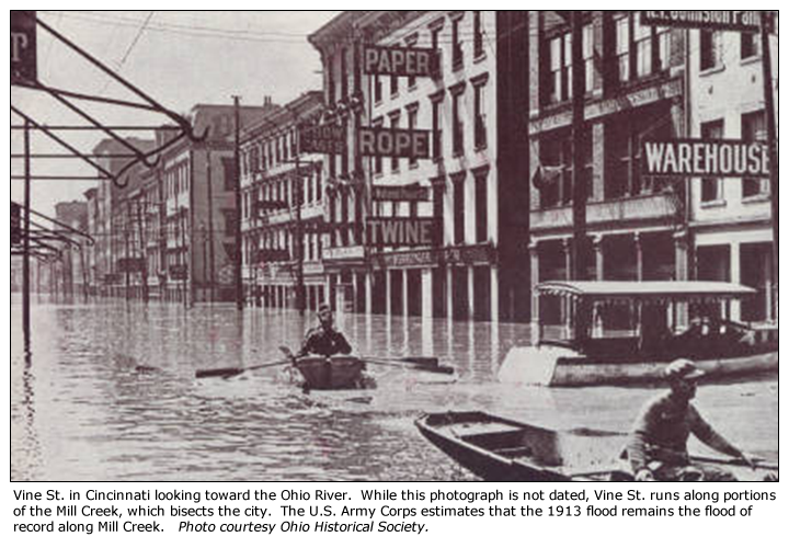
Cincinnati’s first encounter with the 1913 flood came first in the form of rapid flooding along Mill Creek, which originates in Southeast Butler County, and ran through a corridor of combined residential and industrial buildings, as well as many businesses located close to the creek. This initial round of Cincinnati flooding was followed by a cry for help from flood-ravaged Hamilton, Ohio – in Butler County, just north of Cincinnati.
Mayor Henry T. Hunt organized relief efforts primarily to Hamilton, but also to Middletown and Dayton. Relief supplied included boats, medical supplies and personnel, police and food. Mayor Hunt also directed the relief efforts for Middletown and Hamilton until local officials were able to take on the responsibility, having initially been stranded by the massive flooding, with local government buildings in both cities being ravaged by the flood.
Cincinnati is located along the northern bank of the Ohio River, with the outskirts of the city bordered at the east by the Little Miami River, and the west by the Great Miami River, with a very quick-responding Mill Creek running through the heart of the city. The 1937 Ohio River crest of nearly 80’ remains the flood of record to this day, surpassing the 1913 crest by 10 feet. What is not commonly appreciated is that the 1913 flood remains to this day the record flood for the Great Miami, the Little Miami and Mill Creek.
When the massive crest along the Great Miami emptied into the Ohio River in a rural area of Hamilton County downstream of Cincinnati, the Ohio was already rising due to flooding emptying from the Little Miami River and other smaller basins nearby. The Ohio River at Cincinnati rose at a rare rate of 20 feet in a 24 hour period when the river rose from about 29 feet on the morning of March 25th to the 50 foot flood stage by the morning of March 26th. Even the flood of record of 1937 did not have this rapid rate of rise. The explanation at the time by the U.S. Weather Bureau was that the massive volume of water pouring out of the Great Miami had backed up all the way to Cincinnati, 15 miles upstream, and was largely responsible for the rapid rate of rise. After this initial high rate of rise, the rate slowed considerably, as the record river crests from the Muskingum and Scioto watersheds needed several days to reach Cincinnati. This slowing of the rate of rise at Cincinnati was the likely cause of the low fatality count, which was limited to one.
A similar flood in terms of rate of rise along the Ohio River at Cincinnati was the major flood of March 1997, where the river rose from roughly 31’ the morning of March 1st, to 51’ the morning of March 2nd. The river would eventually crest just shy of 65’.
Flood Protection Measures
The city of Cincinnati’s greatest impact from both the 1913 flood and the record crest in 1937 was the combination of flash flooding along the small Mill Creek basin, and then by the eventual crest on the Ohio River itself, which flooded the Ohio River waterfront, but also resulted in massive backwater flooding up the Mill Creek valley.
In order to mitigate flooding in Cincinnati, locations would need to be protected from both Mill Creek and the Ohio River. Flood control measures for the city have been a combined effort of the U.S. Army Corps of engineers, and the city itself. The Mill Creek Barrier Dam was built after the 1937 record flood, and it protects the Mill Creek valley from Ohio River backwater to a stage of 83’, or 3’ higher than the 1937 flood of record. In addition, there are nearly 40 U.S. Army Corps dual purpose lakes located on tributaries to the Ohio River upstream of Cincinnati. These lakes aid in reducing the total volume of water along the Ohio River and its tributaries in the event of a flood. Cincinnati itself has modified development along the riverfront in order to better accommodate a flooded Ohio River, and has various flood gates which are installed during times of high water. Neighboring communities of Covington and Newport, KY and Lawrenceburg, IN have invested in flood walls and levees to protect these communities to at least the 1937 record flood.