The Great Flood of 1913
100 Years Later

Community Profiles: Akron, Ohio
| River: | Cuyahoga and Tuscarawas (Nimishillen Creek tributary) |
| Storm Total Rainfall: | 9.75" |
| Known Fatalities: | None known |
Timeline
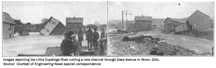
The city of Akron is located in Summit County and is situated upstream of Cleveland on the Cuyahoga River. Historically, the worst flood in Summit County occurred in March 1913 and was estimated to be a 1-percent annual chance flood. During a 60-hour period, approximately 10 inches of rain fell over wide areas. The Little Cuyahoga and the Ohio River flow through the heart of Akron and into the Cuyahoga River which eventually flows into Lake Erie. The Little Cuyahoga came out of its banks on March 25th around 1:00 p.m., flooding city streets and the railroad by several feet.
Just south of Akron is the Tuscarawas River which flows west and feeds the Ohio Canal. In the Tuscarawas Basin lie the reservoirs called the Portage Lakes. Fear of Portage Lakes East Reservoir’s banks failing caused locals to sandbag and save the lake from flooding several homes. Their efforts were not enough to prevent the reservoir banks from bursting which sent a tremendous quantity of water into the Ohio and Erie Canal.
Impacts
The Little Cuyahoga River spilled over its banks and destroyed approximately 30 homes in Akron. Businesses along the Little Cuyahoga, including the Goodyear Tire factory, were severely flooded. On Case Avenue at least 15 homes were destroyed. The washout of the railroad tracks destroyed several freight cars. Several bridges were swept away.
As a result of the bursting reservoir banks in the Tuscarawas Basin sending a huge volume of water into the Ohio and Erie Canal, several locks were destroyed either by the flood waters or the use of dynamiting by local officials to reduce the pressure on the river. The canal was never reconstructed for commerce, and today remains only as a supply channel for processing water to industries. The water passing south into the Tuscarawas River caused considerable damage to property, bridges, and the Ohio Canal. The city's sewer drainage was washed out along the canal towpath. The water supply was greatly affected, and with a dry summer in 1913, the water situation in Akron became very low as the Tuscarawas River flow proved inadequate. Several dams were overtopped in Akron, but the only ones that were destroyed were old timber structures.
Flood Protection Measures
The severity of flooding experienced in 1913 is not likely to recur, in view of the significant improvements that have since been constructed in both the Cuyahoga River and Tuscarawas River drainage basins. East Branch Reservoir, LaDue Reservoir and Lake Rockwell Reservoir presently control about 205 square miles of Cuyahoga River drainage area and have a significant modifying effect upon flood discharges in the upper basin. Mogadore Reservoir has a similar effect upon the Little Cuyahoga River by controlling 12 square miles of headwater area. These reservoirs serve in domestic and industrial water supply and flood control efforts. In addition, a gated flood control works has been constructed at Long Lake outlet to the Tuscarawas River. The City of Barberton has constructed a reservoir in Wolf Creek. Intended as a water supply reservoir, this structure has a modifying effect on flood hydrology. In view of these alterations, it is apparent that the storm drainage basin characteristics in Summit County are significantly improved over those which existed in 1913, and, as such, flooding hazards are of lesser magnitude in comparison.
The county lies in close proximity to the Akron-Canton Airport Weather Station established by the National Oceanic and Atmospheric Administration; therefore, Summit County benefits from a flood warning system operated there. This fact, coupled with prompt action on the part of the county, has contributed much to reducing damage and preventing loss of life during floods. In addition, Summit County has cleaned Mud Run and Pigeon Creek and has widened many areas, which reduces flooding by improving characteristics in the channel.