April 2019
Monthly Overview - April 2019
Slightly Above Average April, Wet Year-to-Date and Record Wet Past 12 Months
Precipitation in April was above normal for the majority of the Midwest
(Figure 1). Below-normal totals were limited to Iowa, Missouri, and small areas in west central Illinois and eastern Kentucky. Above-normal areas extended across southern Minnesota, northern and central Wisconsin, and Upper Michigan and also from southeastern Missouri and western and central Kentucky north to northern Illinois, southern Michigan and northern Ohio. The region as a whole saw totals average 0.25" above normal in April which is 108% of normal. January to April 2019, year-to-date, ranks as the 7th wettest such period (1895-2019) with 133% of normal precipitation (Figure 2). The 4-month total of 12.38" was 3.04" above normal. Seven Midwestern states ranked from 6th to 12th wettest, putting them in the wettest 10% of their histories for January to April. May 2018 to April 2019 ranks as the wettest May to April period on record for the Midwest with over 45". The total was more than 8" above normal
(Figure 3) and more than 1 inch above the old record set in 2010-2011. All nine Midwestern states had above-normal precipitation for May to April ranging from 103% of normal in Missouri to 136% of normal in both Iowa and Kentucky. Three states also set new records for May to April precipitation. Wisconsin topped its 2010-2011 record by less than a half inch (by 0.41"), Iowa easily surpassed its very old record from 1902-1903 (by 2.57"), and Kentucky smashed its previous 1974-1975 record by almost 5 1/2 inches (5.49"). Five other Midwestern states ranked among their five wettest May to April periods with Ohio ranking 2nd, Indiana and Michigan ranking 3rd, Minnesota 4th, and Illinois 5th wettest.
Near Normal Temperatures
April temperatures for the region came in right at normal. Three northern states were below normal, Illinois also came in at normal, and the remaining five were above normal (Figure 4). Most of the daily temperature records in April were record lows. Record lows (433) far exceeded the record highs (115) during the month. Year-to-date temperatures for the region were 2.2° F below normal
(Figure 5). May 2018 to April 2019 (Figure 6) came in at slightly warmer than normal (+0.3° F), however two states ranked among the warmest in their histories, Kentucky ranked 6th and Ohio 8th for the 12-month period.
Delayed Planting
Spring planting was on held up due to wet and cold conditions in the region. Corn planting was running behind the 5-year average in all nine states
(Figure 7). Illinois was furthest behind with just 9% of the crop planted compared to the 5-year average of 43%. Missouri, Minnesota, Indiana, and Ohio were all at least 10% behind average as well. Even normal precipitation would delay field work as soils are saturated with standing water in many fields
April Snow
Snow in April was well above normal in much of Minnesota, Wisconsin, northern Illinois, and parts of Lower Michigan (Figure 8). Totals were two to five times normal in these areas
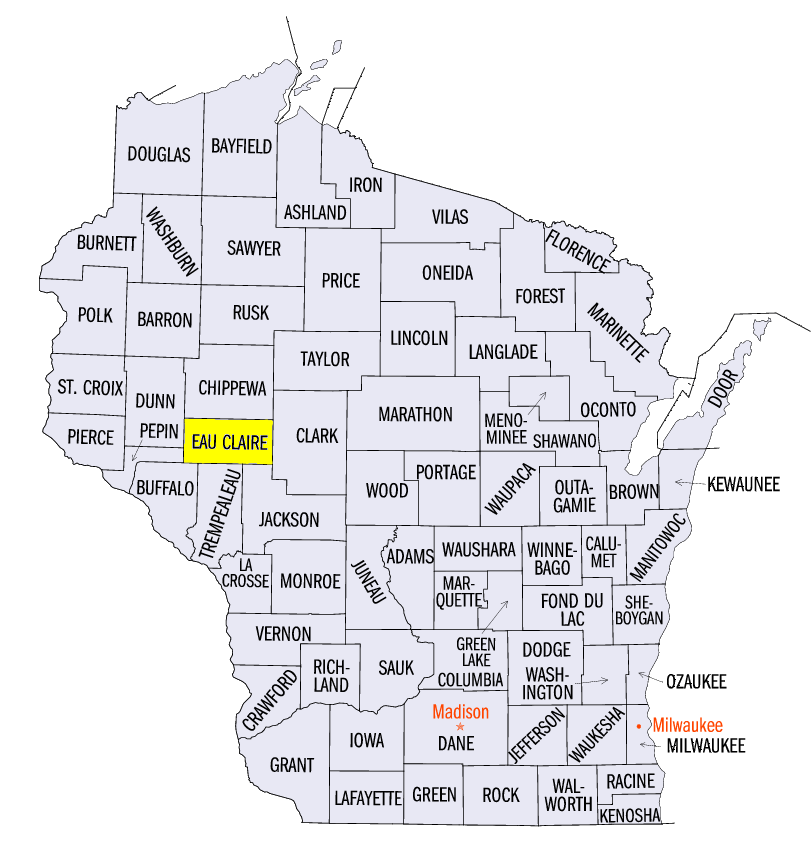
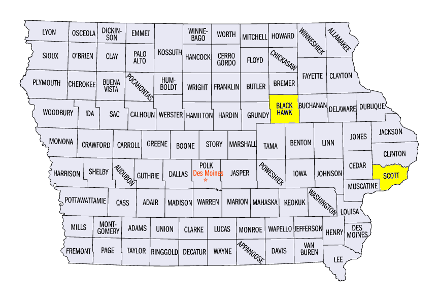
(Figure 9). On the other end of the spectrum, northeastern Ohio was well below normal. A similar pattern for the season was shown with low snow totals in the southeastern Midwest and above normal amounts in much of the western Midwest up through Minnesota and Wisconsin. Totals for the season (Figure 10) were as much as 20" to 30" below normal in northeastern Ohio while areas with 10" above normal stretched across northern and central Missouri, northwestern Illinois, and much of Iowa, Minnesota, Wisconsin, and Upper Michigan. There were areas of western Minnesota and west central Wisconsin that had more than 40" above normal snowfall. Several cities in the upper Midwest set new seasonal snowfall records in 2018-2019. Some notable records were Eau Claire
(Eau Claire County), Wisconsin (126 years) with 98.8", Waterloo
(Black Hawk County), Iowa (122 years) with 60.0", and Rochester
(Olmsted County), Minnesota (86 years) with 86.8".
Extensive and Persistent Flooding
Flooding was both extensive and persistent throughout April in the Midwest
(Figure 11). Flooding was an issue on the major rivers of the region, Mississippi, Missouri, and Ohio Rivers, as well as on their tributaries due to both rainfall and snowmelt. Davenport, Iowa
(Scott County) had been at major flood stage for 38 days as April came to an end, with forecasts that would challenge the record levels of 1993. On the 30th, a levee protecting the downtown area was breached and 6 feet of water quickly engulfed parts of the city. Flood forecasts were indicating that even normal rainfall in the coming weeks could lead to even more impacts with saturated soils and already full waterways.
Severe Weather
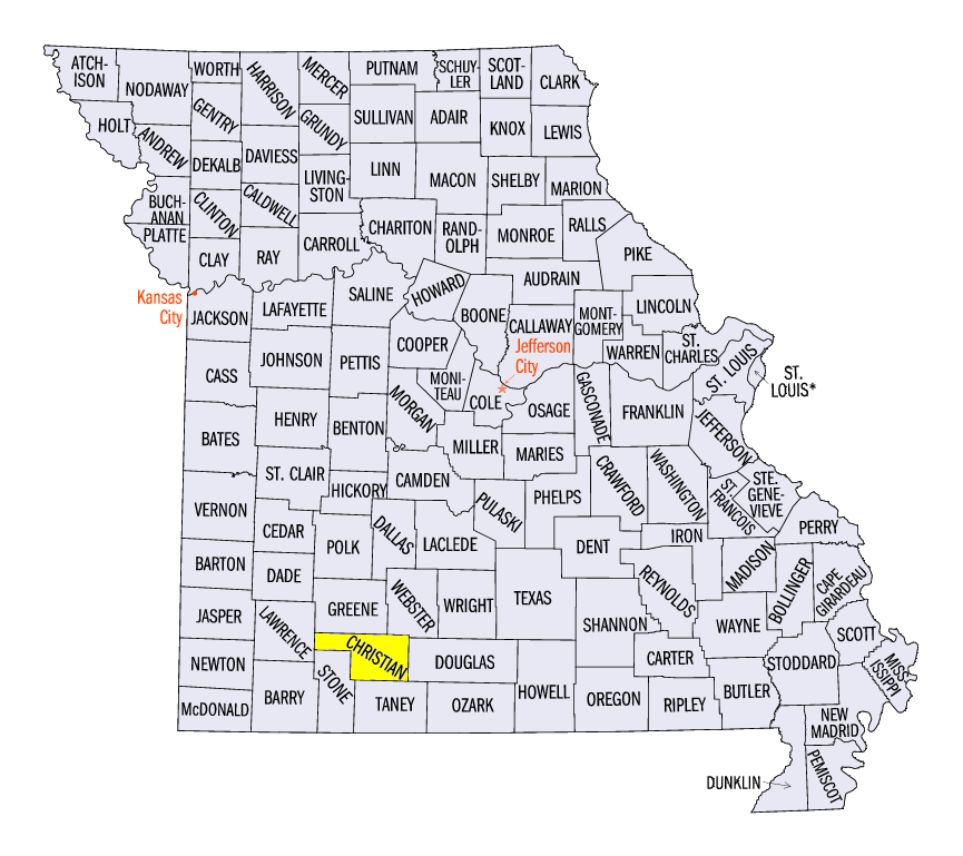
Severe weather was reported in the Midwest on just 13 days in April, and only nine of those days had more than a handful of reports in the region. The northern states were particularly quiet with just a handful of reports in Minnesota and Wisconsin and none in Michigan. Missouri and Ohio were the most active states. Tornadoes were reported on seven days with most of the reports coming from Ohio, particularly on the 14th (Figure 12), and Missouri, particularly on the 30th
(Figure 13). An EF-2 tornado in Christian County, Missouri was responsible for three injuries on the 30th.
Lack of Drought Continues
Drought has been absent from the Midwest throughout 2019 (Figure 14), a record 18 straight weeks (US Drought Monitor history started in 2000). The most recent Midwest drought in the US Drought Monitor was depicted in southwestern Missouri on December 25, 2018. The lack of drought and even abnormally dry areas in the Midwest for the past 10 weeks is also unprecedented in the US Drought Monitor history. The most recent abnormally dry area in the Midwest was a small area in northwestern Minnesota in the February 19, 2019 US Drought Monitor. Prior to this stretch there were only two other weeks, one week in May 2002 and another in May 2017, where the 9-state Midwest had neither drought nor abnormally dry anywhere in the region.
-MST-