On the Road: AZ - AMS Conference SC - RISA Meeting IL - Roundtable on
Climate Change IL - 2015 Extension
Agronomy Day
MRCC Welcomes Two New Climatologists
Beth Hall, MRCC Director
In November, the MRCC welcomed two new climatologists, one that is leading the MRCC Service Office and the other that will be helping with everything from outreach to climate monitoring to research. We are so excited to have them with us and are looking forward to all of you meeting, emailing, or calling them for your latest climate needs and collaborations!
Bryan joined the MRCC as Service Climatologist and is leading the MRCC Service Office. If you ever need historical climate data or a tool for understanding climate patterns over recent years, he is the guy you will want to contact! Whether by phone (217-244-8226) or email, he is there during regular business hours to help you out with any services the MRCC provides, especially data requests and certification of most data. His responsibilities are divided between the Service Office and MRCC research and product development projects.
Before joining the MRCC, Bryan was a meteorologist in the private sector. He interned at the MRCC in 2011 and also at the NOAA Chesapeake Bay Office, in between studying Atmospheric and Oceanic Science at the University of Wisconsin-Madison. While at UW-Madison, he focused on creating a climatology of bombogenesis (the development of a massive, rapidly forming storm) events in the Northeast Pacific Ocean for his undergraduate research.
Olivia Kellner joined the MRCC as a multi-faceted climatologist while completing her PhD dissertation as a doctoral student at Purdue University. Olivia obtained her BS in Geography – Operational Meteorology and Climatology (Professional Track) from Ball State University in 2008 and her MS in Atmospheric Science from Purdue University in August 2011.
Professional experience includes working as a SCEP (Student Career Experience Program) and Meteorologist Intern at the National Weather Service offices in Indianapolis and Milwaukee, and serving as a Staff Scientist at Lee and Ryan (an environmental consulting firm) in the environmental department.
While pursuing her PhD at Purdue, Olivia served as a Climate Specialist/ Assistant Climatologist at the Indiana State Climate Office. Academic research includes land-surface interactions and feedbacks to weather and climate across spatial and temporal scales. Additional research interests include mesoscale convection, applied climatology, remote sensing, and GIS.
Olivia will be working with Molly Woloszyn on outreach and education activities, Mike Timlin on regional climate monitoring and reports, and the entire MRCC staff on research and climate product tool development.
Molly Woloszyn, Extension Climatologist with Illinois-Indiana Sea Grant and MRCC
After a mild start to fall with near normal temperatures in September and October, November abruptly turned cold in the Midwest, giving the region an early dose of winter. The unseasonably cold temperatures spread across the Midwest around November 12th and persisted through almost the end of the month. One of the coldest days was November 17th, where maximum daily temperatures of less than 30°F were widespread across the Midwest and a few single digit maximum temperatures were recorded in southern Minnesota and northern Iowa (figure 1). With a preliminary average temperature of 31.4°F, November 2014 is now the 6th coldest November in the Midwest since records began in 1895.
However, warmer temperatures made their way across the region as November came to a close. In fact, NOAA’s Climate Prediction Center (CPC) called for a pattern change for December, forecasting a good chance that a majority of the United States will experience much milder conditions including above normal temperatures across the Midwest (figure 2).
In the Midwest, so far this winter season we have seen a mix of colder-than-normal and warmer-than-normal temperatures. So what does the rest of the 2014-2015 winter season have in store for the region?
Accurate seasonal outlooks are difficult to provide, especially when there is no strong signal or driver in the atmosphere, which is the situation this year. What do I mean by “signal” or “driver”? I am talking about phenomena such as El Niño, which is the existence of unusually warm sea surface temperatures in the equatorial Pacific Ocean. Based on previous years with a strong El Niño present in the equatorial Pacific Ocean, winters in the Midwest tend to be warmer than normal, with the chance for drier than normal conditions, specifically in the eastern Midwest. There is a 65% chance El Niño could develop this winter. However, if it emerges, it is likely to be weak, making it an undependable driver when it comes to this winter’s outlook.
Therefore, NOAA’s CPC seasonal outlook for the December 2014-February 2015 time frame shows no clear signal for much of the Midwest on whether temperatures will be above, near, or below normal (figure 3). There is a slight chance, however, for below normal temperatures in southern portions of the region.
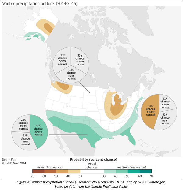
In terms of precipitation, CPC is calling for greater chances of below normal precipitation in portions of the eastern Midwest, which is reflecting the possibility for weak El Niño development (figure 4). There is no clear signal for the rest of the region on whether precipitation will be above, near, or below normal for December 2014-February 2015.
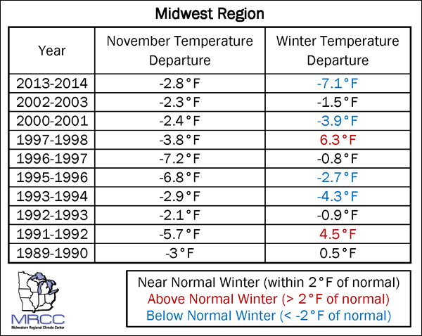
Are there any other methods to make predictions for the upcoming 2014-2015 winter season? Well, we already know that November 2014 was ranked 6th coldest in the Midwest. What can climatology tell us by looking at previous cold Novembers in the region and what it might mean for the upcoming winter? Looking at the ten most recent cold Novembers in the Midwest, four were followed by a colder-than-normal winter, two were followed by a warmer-than-normal winter, and four were followed by a near-normal winter (near normal is defined as within 2°F of normal) (figure 5). As you can see, it’s been a mix. Therefore, the cold November this year is not necessarily an indicator for a cold winter ahead – although, a cold winter is not out of the question.
Figure 5
Some seasonal outlooks are pointing to the possibility for a colder-than-normal winter in the Midwest. For instance, research suggests a correlation between rapid snow advancement and overall extent across Siberia and Eurasia during October and colder-than-normal winter temperatures and more snowfall across the eastern United States. In October 2014, snow cover advance and extent across Eurasia was the 2nd highest in the satellite era which began in the 1970s, meaning a chance for a cold and snowy winter here in the Midwest according to this study.
Another indicator pointing towards a cold Midwest winter is the existence of a positive Pacific Decadal Oscillation (PDO), which represents a warmer-than-normal pattern of sea surface temperatures in the central and northern Pacific Oceans. Since the late 1990s, the PDO has been predominantly negative but has shifted to positive in 2014. A positive PDO tends to support colder winter season conditions across the eastern United States. A special thanks to the Chicago National Weather Service for the information presented in these last two paragraphs, which came from their winter 2014-15 outlook.
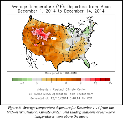
To wrap up, I wish I had a formula to tell you exactly what the winter of 2014-2015 has in store for us here in the Midwest. Unfortunately, I have to tell you that it really is difficult to determine at this point. Keep in mind those drivers (October snow cover and extent on Eurasia and a positive Pacific Decadal Oscillation) pointing towards increased chances for a cold and snowy winter in the Midwest. In the meantime, enjoy the mild December temperatures that we have had so far this month (figure 6), and those forecast in the days leading into the holiday season (figure 7)!
For more information on this article, please contact Molly Woloszyn via email at mollyw@illinois.edu
November was a cool month across the Midwest. Temperatures were below normal by 5°F to 10°F with the largest departures in Minnesota. All nine Midwest states ranked among the 15 coldest Novembers in the 120 year record (1895 to 2014). The region as a whole ranked as the 6th coldest November and the individual states ranked from 3rd to 15th.
November's cool weather continued a pattern of cool weather for the region in 2014. January to November of 2014 ranked as the 5th coldest such period in 120 years. Statewide values ranked from 3rd (IL, MO, and WI) to 13th (MN). The first half of December has gotten off to a slightly above normal start, particularly in the western states and Kentucky. Read more...
Researchers from the Regional Climate Centers and the National Weather Service have developed a tool to monitor and objectively index winter conditions across the U.S. The index values can be compared to other years at the same location to gauge of the severity of a given winter. The index values can also be compared at differing locations to compare winter severity among the various cities. The AWSSI will be updated throughout the current winter season at selected locations. Watch for updates throughout the winter on the AWSSI web page.
NOAA's National Climatic Data Center is now producing the Regional Snowfall Index (RSI) for significant snowstorms that impact the eastern two thirds of the U.S. The RSI ranks snowstorm impacts on a scale from 1 to 5, similar to the Fujita scale for tornadoes or the Saffir-Simpson scale for hurricanes.
Category
RSI Value
Description
1
1–3
Notable
2
3–6
Significant
3
6–10
Major
4
10–18
Crippling
5
18.0+
Extreme
The RSI differs from these other indices because it includes population. RSI is based on the spatial extent of the storm, the amount of snowfall, and the juxtaposition of these elements with population. Including population information ties the index to societal impacts. Currently, the index uses population based on the 2000 Census and contains snowstorms beginning in 1900.
Phoenix, Arizona (January 4-8) — American Meteorological Society Meeting Mike Timlin, Zoe Zaloudek, and Beth Hall will be attending and presenting at the 95th AMS annual meeting in Phoenix. The meeting theme is "Fulfilling the Vision of Weather, Water, and Climate Information for Every Need, Time, and Place."
Charleston, South Carolina (January 13-15) — Regional Integrated Science and Assessments Meeting
Beth Hall will be attending the Regional Integrated Science and Assessments (RISA) meeting, which brings together NOAA RISA program partners from around the country.
Galena, Illinois (January 14) — Galena Rotary Club's "Roundtable of Climate Change" The Galena Rotary Club program, conducted in cooperation with Galena Gazette Publications and the University of Illinois Extension, will feature Olivia Kellner, who will give a talk on climate change. This is their 27th annual Community Roundtable.
Litchfield, Illinois (February 19) — 2015 West-Central Illinois Agronomy Day Olivia Kellner will give a talk on climate change topics in the Midwest at the 2015 University of Illinois Extension Agronomy Day for West-Central Illinois.
Email us your local climate impacts! We are constantly keeping a log of how climate is impacting
our region, and our information would not be complete with YOUR help!
Have something to share as a feature article in an upcoming The Climate Observer issue, or
interested in being contacted for an article interview? Please let us know!


 Bryan Peake
 Olivia Kellner
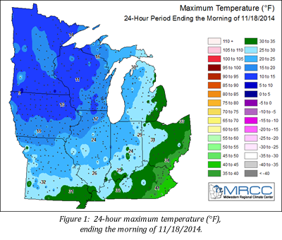 After a mild start to fall with near normal temperatures in September and October, November abruptly turned cold in the Midwest, giving the region an early dose of winter. The unseasonably cold temperatures spread across the Midwest around November 12th and persisted through almost the end of the month. One of the coldest days was November 17th, where maximum daily temperatures of less than 30°F were widespread across the Midwest and a few single digit maximum temperatures were recorded in southern Minnesota and northern Iowa (figure 1). With a preliminary average temperature of 31.4°F, November 2014 is now the 6th coldest November in the Midwest since records began in 1895.
 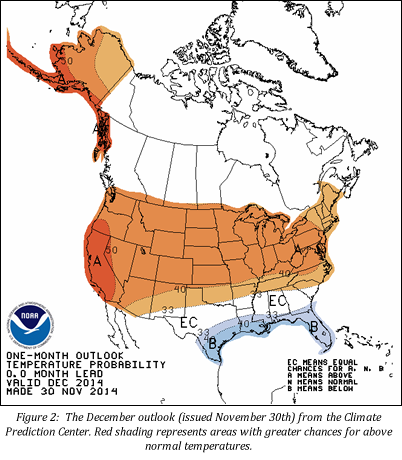 However, warmer temperatures made their way across the region as November came to a close. In fact,
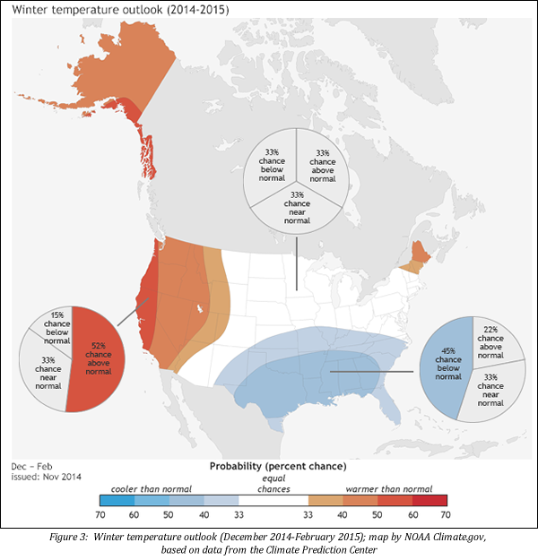
 Another indicator pointing towards a cold Midwest winter is the existence of a positive Pacific Decadal Oscillation (PDO), which represents a warmer-than-normal pattern of sea surface temperatures in the central and northern Pacific Oceans. Since the late 1990s, the PDO has been predominantly negative but has shifted to positive in 2014. A positive PDO tends to support colder winter season conditions across the eastern United States. A special thanks to the Chicago National Weather Service for the information presented in these last two paragraphs, which came from their winter 2014-15 outlook.
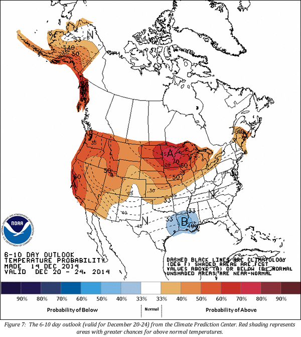
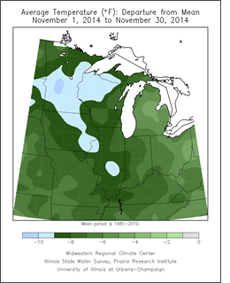 November was a cool month across the Midwest. Temperatures were below normal by 5°F to 10°F with the largest departures in Minnesota. All nine Midwest states ranked among the 15 coldest Novembers in the 120 year record (1895 to 2014). The region as a whole ranked as the 6th coldest November and the individual states ranked from 3rd to 15th.
 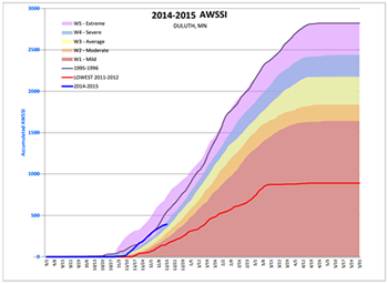 Accumulated Winter Season Severity Index (AWSSI):
  NOAA's National Climatic Data Center is now producing the
  Phoenix, Arizona (January 4-8) — American Meteorological Society Meeting